


What Lake Bonneville Left Behind: The Geological History of Utah’s Bonneville Salt Flats
At its height, Lake Bonneville must have been an extraordinary sight. During the Ice Age, this enormous lake covered much of western Utah and extended into parts of Nevada and Idaho. It was approximately the size of Lake Michigan. As the climate changed and the lake receded, it left behind a remarkably flat, bright landscape of playas, salt flats, mineral deposits, and wave-carved shorelines. Today, this former lakebed is associated with geological discoveries, engineering achievements, speed records, and some of the most dramatic stories of western exploration.
How Lake Bonneville Formed
Lake Bonneville began forming approximately 55,000 years ago during a cool and unusually wet period in the region that is now southeastern Idaho. Geological changes redirected the Bear River, allowing water to accumulate in the Gem Valley and other basins farther south.
A natural geological dam at Red Rock Pass helped contain the growing lake for thousands of years. Over time, Lake Bonneville expanded across a vast portion of the Great Basin, reaching its maximum level during the late Pleistocene.
The Bonneville Flood and the Decline of the Ice Age Lake
Approximately 18,000 years ago, water breached the natural dam at Red Rock Pass. The resulting Bonneville Flood sent a powerful torrent into the Snake River and Columbia River systems. The flood continued for roughly six weeks and caused the lake level to fall by more than 350 feet, or about 105 meters.
As the climate gradually became warmer and drier, Lake Bonneville continued to shrink. Its remaining waters eventually formed smaller modern lakes, including the Great Salt Lake, Utah Lake, and Lake Sevier. Although Lake Bonneville disappeared thousands of years ago, its shoreline and lakebed still shape the landscape of the Great Basin.
How Satellite Images Reveal Lake Bonneville’s Ancient Shoreline
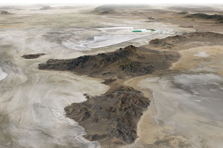
The former lake is still visible in satellite imagery. In the image captured by the Operational Land Imager (OLI) aboard the NASA-USGS Landsat 8 satellite, bathtub-like shoreline rings and wave-cut terraces trace the ancient coastline of Lake Bonneville.
The dry lakebed consists of fine-grained clay, marl, sand, and other sediment deposited by the ancient lake. These pale materials stand out against the darker, rockier, and more densely vegetated terrain surrounding the Bonneville Salt Flats.
Mineral Deposits and Salt Flats
In the deepest portions of the former Lake Bonneville basin, water and groundwater continue to collect. As this water evaporates, it leaves behind light-colored deposits of evaporite minerals.
These extremely flat surfaces allow water to evaporate slowly while dissolved minerals become increasingly concentrated. The process produces brine and hard mineral crusts that commonly contain halite, gypsum, potassium salts, and magnesium salts. Deposits of potash have supported mining operations for decades. The rectangular evaporation ponds visible in satellite images are used to concentrate potash for agricultural fertilizer.
The Mountains Surrounding the Bonneville Playa
The dark, rugged mountains rising above the playa—including the Silver Island Mountains, Newfoundland Mountains, and Pilot Mountains—are made of erosion-resistant sedimentary and metasedimentary bedrock. Some of these rocks formed hundreds of millions of years ago.
The mountain ranges also contain younger metamorphic and igneous rocks created when heat, pressure, and magma altered older sedimentary layers. The contrast between the pale playa and dark mountain ridges makes the region especially striking in aerial and satellite photographs.
Crater Island: A Geological Analogue for Venus
Crater Island provides another example of the region’s complex geology. The island contains sedimentary rocks such as silica-rich sandstone and quartzite, which formed from sand deposited in ancient shallow seas. It also includes intrusive rocks such as quartz monzonite and granite, types of igneous rock formed when molten material cooled beneath Earth’s surface.
Later movement and expansion of Earth’s crust produced fault-block mountains, helping create the dramatic topography visible throughout the Bonneville Salt Flats region.
In June 2026, scientists and engineers working with NASA’s DAVINCI mission visited Crater Island, which researchers describe as an Earth-based analogue for Venus. The team conducted field tests on camera systems and equipment designed to descend through Venus’s dense atmosphere and photograph its mountainous terrain in unprecedented detail.
During its planned descent, the DAVINCI spacecraft will capture near-infrared images, analyze atmospheric chemistry, and study the environment of Venus. During rehearsals at Crater Island, engineers suspended the camera system beneath a helicopter and lowered it toward the surface while collecting hundreds of images of iron-rich and silica-rich rock formations.
Using only imagery from the test camera system, researchers produced a three-dimensional map of the area that matched an existing geological map. The successful test increased confidence that similar imaging techniques could help map the Alpha region of Venus, one of the areas DAVINCI is expected to study.
Bonneville Salt Flats Speed Records
The remarkably flat and smooth surface of the Bonneville Salt Flats has also made it a legendary venue for land-speed record attempts. In 1960, Mickey Thompson became the first American to exceed 400 miles per hour. Driving the streamlined Challenger 1 race car, he reached 406.60 miles per hour, or 654.36 kilometers per hour, at the Bonneville Salt Flats. The achievement earned him the nickname “The Fastest Man on Earth.”
The salt flats continue to attract experimental vehicles and engineering teams pursuing new speed records. In August 2026, reports described a hydrogen-powered vehicle reaching approximately 406.320 miles per hour, or 653.909 kilometers per hour, during a record-setting test. By using hydrogen rather than gasoline, the vehicle was designed to avoid producing carbon dioxide during combustion.
The Donner-Reed Party and the Bonneville Desert
The Bonneville playa also played a role in one of the most difficult journeys in American migration history. In August 1846, members of the ill-fated Donner-Reed Party traveled near the southern end of Crater Island while attempting to follow a shortcut toward Pilot Peak.
Their route led from Hastings Pass, past Floating Island, and toward Donner Springs. The journey quickly became more difficult when heavy wagons broke through the thin salt crust and became trapped in the mud beneath it. The delays and hardships forced the group to abandon several wagons in the desert.
NASA Earth Observatory image by Michala Garrison using Landsat data from the United States Geological Survey. Story by Adam Voiland.

June 4, 2026: Crater Island Geological Map
References
- Center for Land Use Interpretation; Intrepid Potash Wendover. Accessed August 21, 2026.
- Garvin, J. B., et al. (2022). Uncovering the Mysteries of Venus: The DAVINCI Mission. Planetary Science Journal, 3(117).
- Hill Air Force Base (January 28, 2026). Travel Traces: Donner-Reed Wagon Site on the Hastings Trail. Accessed August 21, 2026.
- Idaho State University. Lake Bonneville Flooding. Accessed August 21, 2026.
- NASA (July 14, 2026). Utah Helicopter Flight Tests NASA’s DAVINCI Mission to Venus. Accessed August 21, 2026.
- NASA. DAVINCI Mission. Accessed August 21, 2026.
- NASA Earth Observatory (February 25, 2018). Bonneville Salt Flats. Accessed August 21, 2026.
- National Park Service. Donner and Reed Wagon Train Incident. Accessed August 21, 2026.
- Utah Geological Survey. Lake Bonneville. Accessed August 21, 2026.
- Utah Geological Survey. Geological History. Accessed August 21, 2026.
- Utah Geological Survey. Great Salt Lake and Lake Bonneville. Accessed August 21, 2026.
- Utah Department of Natural Resources (1990). Geological Map of the Rulon 4 SW Quadrangle. Accessed August 21, 2026.
Source: science.nasa.gov