


Congaree National Park: Exploring South Carolina’s Ancient Floodplain Forest
Of the 63 national parks in the United States, few are shaped so completely by a single river. Congaree National Park in South Carolina is one of them. Approximately 80 percent of the park lies within the Congaree River floodplain, creating a landscape defined by seasonal flooding, wetlands, and towering hardwood trees.
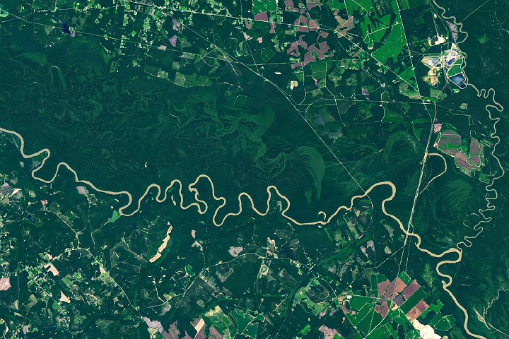
Congaree protects one of the largest remaining areas of intact old-growth bottomland hardwood forest in the United States. This Landsat 9 image, captured by the satellite’s Operational Land Imager (OLI), shows the Congaree River winding through a densely forested plain. Curving green bands reveal former river channels, natural levees, ridges, and wetlands created as the river gradually changed course.
These subtle differences in elevation influence how often various parts of the floodplain are inundated. The resulting changes in soil moisture and flooding frequency support distinct ecosystems, which appear in contrasting shades of green from space. Many of the former channels visible in the image are paleochannels—old pathways once occupied by the Congaree River.
How the Congaree River Shapes the Landscape
Rivers flowing across flat, soft terrain frequently form sweeping meanders. Water generally moves faster along the outside of a bend, where it causes erosion along the riverbank. On the inside of the curve, slower-moving water encourages deposition of sand and sediment, creating features known as point bars.
Over time, erosion and deposition can cause a river to abandon a bend and establish a shorter route through its floodplain. The isolated, U-shaped water body left behind is called an oxbow lake. These landforms are among the most visible signs of the Congaree River’s constantly changing course.
Oxbow Lakes and Wetlands in Congaree National Park
According to the National Park Service, Weston Lake is located about 1.9 kilometers (1.2 miles) from the visitor center. It is one of the park’s most permanent oxbow lakes and is notable for being relatively deep, with fewer shallow clay and silt deposits than many other oxbow lakes in Congaree.
Another prominent feature is Devil’s Elbow. The image also shows Bates Old River, an approximately four-mile-long abandoned channel of the Congaree River and one of South Carolina’s longest crescent-shaped lakes.
As abandoned channels and oxbow lakes gradually collect sediment, they become shallower and may develop into wetlands. Some of these water-filled floodplain features are called sloughs. In areas that remain wet or flood frequently, cypress-tupelo forests often thrive.
How Congaree Became a National Park
Loggers began targeting forests along the Congaree River in the 1880s, but difficult conditions limited large-scale timber harvesting. Frequent floods, muddy roads, and dense mosquito populations made the floodplain challenging to access. As a result, much of the forest escaped the widespread logging that transformed other parts of the Southeast.
By the 1950s, conservationists recognized that Congaree’s old-growth floodplain forest had become exceptionally rare. Congress designated the area a national monument in 1976, and Congaree officially became a national park in 2003. Today, it protects one of the most significant remaining old-growth bottomland forests in the United States.
Flooding Fuels Congaree’s Giant Trees
As the Congaree River meanders through the park’s mostly flat terrain, it spills over its banks several times a year. Flooding is most common during winter and early spring, although hurricanes and major storms can also bring floods during summer and fall.
These floods spread nutrient-rich silt across the floodplain, replenishing the soil and supporting the growth of enormous trees. The combination of fertile sediment, abundant water, and protection from logging has helped Congaree develop an unusually high density of large trees.
For decades, Congaree National Park has been known for its extraordinary champion trees, which have held national or state size records for their species. Individual trees may lose champion status because of damage, disease, age, or the discovery of larger specimens elsewhere. However, Congaree has produced record-setting examples of possumhaw (Ilex decidua), water hickory (Carya aquatica), loblolly pine (Pinus taeda), laurel oak (Quercus laurifolia), swamp tupelo (Nyssa biflora), and sweetgum (Liquidambar styraciflua).
Discover Congaree from Space
During National Park Week, explore and celebrate America’s protected landscapes through the Earth Observatory’s collection of satellite images. You can also learn more through From Earth to Sky, a collaborative program connecting NASA scientists with National Park Service rangers and educators across the country.
NASA Earth Observatory image by Michala Garrison, using Landsat data from the United States Geological Survey. Story by Adam Voiland.
Sources
- American Forest (2009), Congaree: Where the Trees Are Still Tall. Accessed August 27, 2026.
- Atlas Obscura (May 12, 2025), How One Biologist Drew an Ultra-Accurate, Ranger-Approved Map of Congaree National Park. Accessed August 27, 2026.
- Discover South Carolina, Champion Trees Are a Major Attraction in Congaree National Park. Accessed August 27, 2026.
- National Parks Conservation Association (March 27, 2024), Congaree: Champion Trees, Synchronous Fireflies, and More. Accessed August 27, 2026.
- National Parks Conservation Association (2017), The Wild Congaree. Accessed August 27, 2026.
- National Park Maps, Congaree Forest Map. Accessed August 27, 2026.
- National Park Service, The Last Stand of Floodplain Forests. Accessed August 27, 2026.
- National Park Service, Congaree National Park. Accessed August 27, 2026.
- National Park Service (2014), Congaree National Park: Geological Resource Inventory Report. Accessed August 27, 2026.
- United States Environmental Protection Agency, Bottomland Hardwood Forests. Accessed August 27, 2026.
- United States Geological Survey, Ecology of Congaree National Park. Accessed August 27, 2026.
Source: science.nasa.gov