


Lake Powell Hits Record Low as Colorado River Snow Drought Deepens in 2026
An intense snow drought and unusually warm weather across the Colorado River Basin in 2026 sharply reduced the amount of water flowing into major reservoirs in the western United States.
By summer, the effects of the weak 2025–2026 mountain snowpack in the Upper Colorado Basin had reached Lake Powell. With far less snowmelt entering the Colorado River than usual, inflows declined and the nation’s second-largest reservoir fell to a record low in late August and early September.
Lake Powell falls below its previous record low
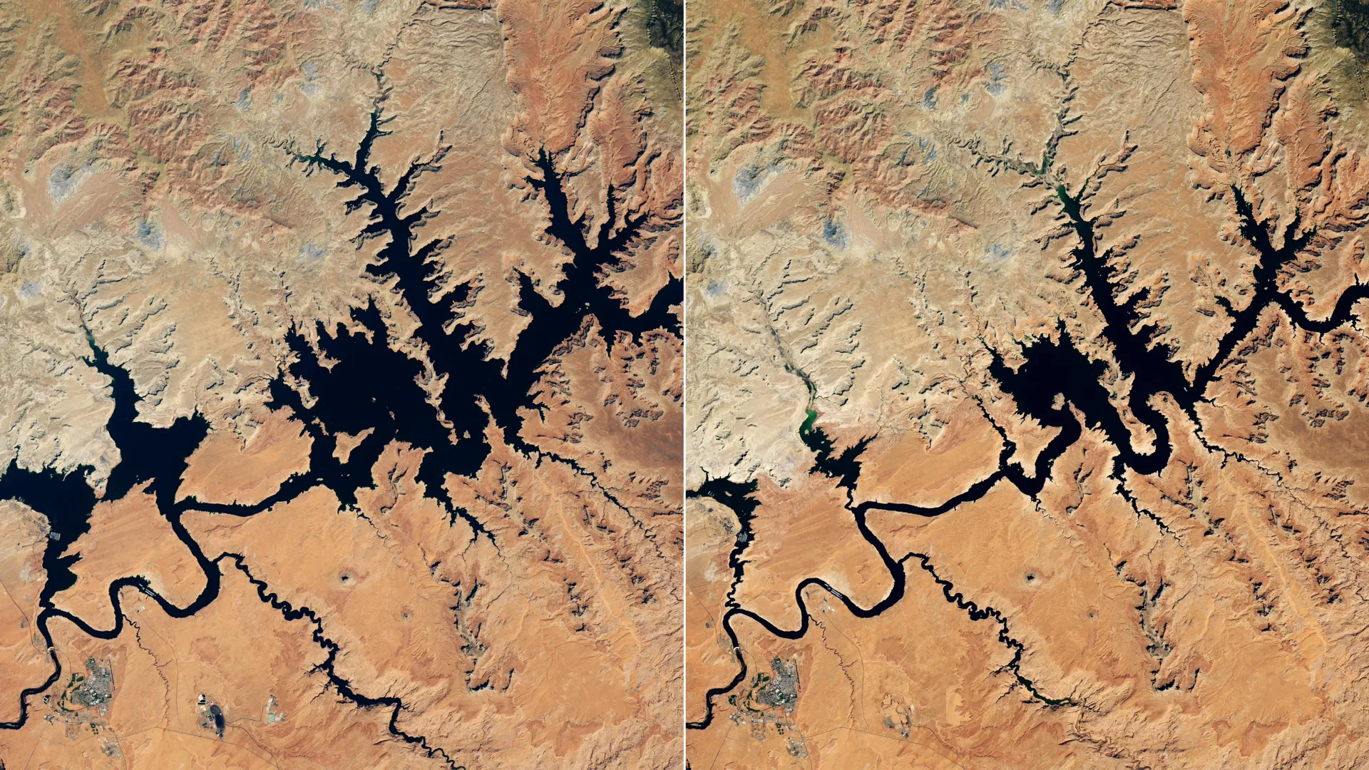
Satellite images show dramatic changes at Lake Powell near Glen Canyon Dam. The images were captured by the Operational Land Imager (OLI) aboard the NASA-USGS Landsat 8 satellite on September 1, 2017, and September 10, 2026.
In the 2026 image, Lake Powell’s water level was 3,517.24 feet. About a month earlier, the reservoir had already fallen below its previous all-time low of 3,519.92 feet, recorded on April 13, 2023. Water levels continued to decline into early September.
By contrast, the 2017 image shows Lake Powell near its highest water level of the past decade.
Lake Mead also reaches a record low
The Colorado River flows first into Lake Powell before continuing downstream toward Lake Mead. Lake Mead also reached an all-time low in August 2026.
The river system is managed by the United States Bureau of Reclamation (USBR) and other agencies. It provides water and power throughout the Southwest, supporting more than 40 million people, including residents of Las Vegas, Phoenix, Los Angeles, and San Diego. The Colorado River also supplies water to approximately 5 million acres of agricultural land.
Why snowpack is critical to the Colorado River
Mountain snowpack is especially important because much of the Colorado Basin is arid or semiarid. Most of the Colorado River’s annual flow begins as snow that accumulates in high-elevation areas during winter and melts in spring and early summer.
The Upper Colorado Basin experienced unusually low snowfall during the winter of 2025–2026, producing a snow drought. A period of record warmth further reduced the mountain snowpack.
As a result, spring snowmelt delivered far less water than usual to Lake Powell and other reservoirs, doing little to relieve already depleted water levels.
Emergency measures aim to protect Lake Powell
In April 2026, USBR began taking steps to stabilize Lake Powell and ensure that reservoirs did not fall below the elevation required for hydropower generation.
Without intervention, officials considered that possibility realistic by August 2026.
To support Lake Powell, USBR began releasing additional water from Flaming Gorge Reservoir in northern Utah and southern Wyoming. At the same time, officials reduced the amount of water released from Lake Powell into Lake Mead.
Officials also canceled a planned controlled flood intended to rebuild sandbars used as fish habitat. In August, authorities postponed the release of “Cool Mix,” a water release designed to protect native species.
A megadrought continues to pressure the Southwest
The southwestern United States has experienced drought since the beginning of the 21st century. Experts describe the prolonged drying period as a megadrought, and it continues to place intense pressure on the region’s limited water supplies.
A NASA-supported project and monitoring system is providing water managers and other decision-makers across the Colorado Basin with more detailed information about drought conditions and how they are changing.
In the headwaters of the Colorado River, the Western Land Data Assimilation System (WLDAS) provides real-time visualizations of soil moisture, snow water equivalent, and evapotranspiration. The information supports the Colorado Drought Task Force and contributes to weekly reports, including the U.S. Drought Monitor map.
Satellite data helps track drought across the Colorado Basin
The Drought Severity Assessment Tool, developed in collaboration with the Navajo Nation, allows leaders to track local drought indicators, precipitation patterns, and vegetation health across tribal lands. Funding from NOAA’s National Integrated Drought Information System expanded its implementation to the Chickasaw and Choctaw Islands of Oklahoma in 2025.
Another resource, the Colorado River Comprehensive Assessment Tool, was developed by researchers at Arizona State University in collaboration with the Central Arizona Project. It combines NASA satellite-verified measurements with improved modeling of snowpack, surface and groundwater storage, soil moisture, and other conditions across the Colorado River Basin in a single interactive system.
Source: www.sciencedaily.com