


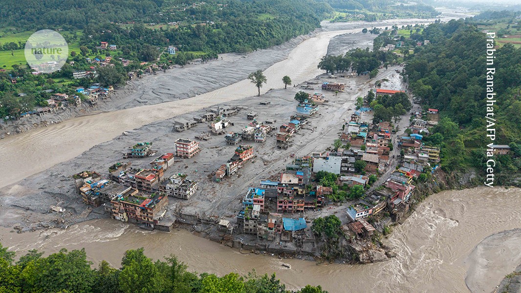
On August 26, an avalanche and severe flooding struck Nepal’s Rasuwa district, killing more than 1,400 people, leaving more than 5,000 missing and destroying homes, roads, bridges and energy infrastructure. The disaster disrupted trade and tourism, cut off about 10% of Nepal’s hydropower generation and is expected to cost roughly $5 billion to rebuild. Its unprecedented scale highlights the need to rethink how cascading hazards in mountain regions are assessed and managed, particularly as global warming increases the likelihood of large rock, ice and debris failures.
A series of huge disasters
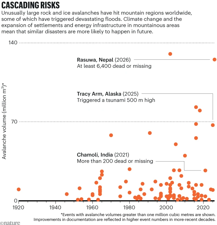
The Rasuwa disaster is not an isolated event. In recent years, several mountain regions have experienced large collapses of rock and ice followed by flooding and other cascading impacts.
Source: MC Matthew et al., Landslides (2024); D. Schneider et al., Earth Surface Processes and Landforms (2011); Y. Chong et al., Landslides (2025); JA Co et al., Landslides (2018); A. Kev et al., The Cryosphere (2021); Alaska Volcano Observatory Annual Report
In India, an avalanche from Mount Ronti caused catastrophic flooding in Chamoli district, Uttarakhand, in February 2021. Water and debris destroyed the Ronti Gad valley, killed more than 200 people and damaged hydroelectric power plant structures.1
Several months later, in June 2021, a small glacial lake in Nepal burst its banks and sent floodwater into the Melamchi River. The resulting chain of events washed away more than 50 million cubic metres of sediment and altered riverbed levels by about 20 metres in some locations.2 About 600 people were evacuated and at least 20 died. Newly installed drinking-water infrastructure was severely damaged, and large areas of farmland were lost.
In October 2023, a massive slide of glacial sediment into South Lhonak Lake in Sikkim, India, triggered another flood. Water carried about 270 million cubic metres of sediment down the lower Teesta River. More than 100 people were killed, approximately 26,000 buildings were damaged and hydroelectric structures were destroyed. The impacts extended into Bangladesh, including damage to infrastructure.3
In May 2025, the Swiss Alpine village of Blatten was buried by an avalanche containing nearly 10 million cubic metres of rock and ice after a glacier collapsed. The glacier had been weakened by a series of rockslides that deposited material on its surface.4 The village was destroyed and one person was killed, although other residents evacuated before the flooding.
Less than three months later, an approximately 64-million-cubic-metre landslide struck South Sawyer Glacier and Tracy Arm Fjord in Alaska.5 It generated a tsunami nearly 500 metres high. The event occurred hours before a cruise ship was due to pass through the fjord, averting a potential maritime disaster.
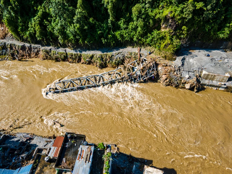
Roads, bridges and other infrastructure were washed away after an avalanche in Nepal in August. Credit: Ambir Tolang/NurPhoto (via Getty)
The Rasuwa disaster surpassed these events in scale. On the northern slopes of Mt. Langtang Lirung, a rock failure triggered a massive rock avalanche that swept away the glacier above it. The resulting avalanche involved approximately 125 million cubic metres of rock, ice and boulders, making it one of the largest on record.
Ice, debris and water flowed down the Rende Kola, Bhotekosi and Trishuli river valleys. Melting ice added water and sediment to the streams, spreading the damage more than 100 kilometres from the source. More than 1,400 people died, more than 5,000 are missing and tens of thousands were evacuated. Settlements, roads and bridges were washed away, and about 10% of Nepal’s hydropower generation was cut off. Reconstruction costs are estimated at approximately $5 billion.
On October 11, Nepal’s central Himalayan region was hit by flooding in the upper reaches of the Budhi Gandaki River. The flooding was caused by another large rock-and-ice avalanche from a steep mountain slope, about half the size of the August collapse. Villages, roads, bridges and hydropower structures were damaged.
Increasing risk and exposure
These disasters resulted from interacting, cascading processes. They can include the collapse of steep rock and glacial slopes, the failure of sediment banks, sudden flooding from lakes and the downstream entrainment of water, debris and sediment.
Scientists have repeatedly emphasized the need to understand such cascading hazards better and incorporate them into risk analyses.6, 7 Yet little has changed in how these hazards and their risks are considered in practice.
The likelihood of a single event is typically estimated from historical records. However, events on the scale now being witnessed are rare or absent from those records. That makes it difficult to predict how often large floods involving avalanches will occur in the future. The number of events observed in recent years is also too small to establish long-term trends.
One point is clear: the world is becoming warmer. In coming decades, this is likely to increase the probability of rock-slope and glacier collapses. Historical events therefore provide an unreliable guide to future conditions.
Development in mountain regions is also expanding the number of people, habitats and infrastructure exposed to these hazards. In Rasuwa’s Trishuli basin, for example, hydropower development has grown since 2010, as has construction along roads leading to the Sino-Nepal Rasuwagadhi-Kerung border.
Re-evaluating risk analysis
Scientists and decision-makers need to rethink how hazards and risks are analysed in mountain regions. Rather than relying on one method, they should combine complementary approaches according to the situation.
The first step is to define the purpose and scope of an assessment. Risk analysis can inform land-use planning, guide funding, identify conservation gaps, estimate potential economic losses or establish risk-management priorities. Assessments may focus on a single hydropower plant or on a densely populated region.
Governments and communities should work together to determine what level of risk is acceptable and how to protect the most vulnerable people and infrastructure.
A combination of assessment techniques is then needed. Each method addresses particular aspects of risk, and the methods complement one another. Disasters such as the one in Rasuwa demonstrate the importance of using multiple tools to understand multidimensional impacts.
Stochastic risk analysis can estimate the distribution of asset losses associated with events of different sizes and frequencies.8 For a hydroelectric power plant, for example, it could provide a statistical representation of potential damage under events with different probabilities.
Probabilistic analysis is difficult, however, when assessing future events with little or no historical precedent. In those cases, analysts can use models based on reliable and physically plausible scenarios. These scenarios can draw on existing knowledge and expert judgement and should cover a broad range of possible events.9
The geological record can provide important clues. At Rasuwa, large boulders well beyond the current riverbed indicate that a similar flood occurred about 5,000 years ago.10 A plausibility analysis can then examine whether such an event could occur under present or near-future conditions.
Assessing cascading effects beyond current populations and infrastructure requires a storyline approach that considers a wide range of possibilities using both qualitative and quantitative methods.11 The Rasuwa disaster, for example, destroyed important trade and transport routes between Nepal and China, affecting Nepal’s economy. Damage to hydropower plants also affects neighbouring countries that depend on energy imports, including Bangladesh.
Risk-network analysis can help address gaps in conventional assessments, including the omission of impacts on disadvantaged populations. Such methods can examine connections between flooded homes and their residents, the loss of local businesses and livelihoods, and disruption to social networks, education and health services.
Source: www.nature.com