


Puerto Rico typically enters its rainy season in May, but 2026 has brought an unusually dry and severe turn. By late August, much of the U.S. territory faced significant rainfall deficits, and drought conditions had expanded rapidly. The lack of precipitation caused water shortages and rationing in several municipalities, prompting Puerto Rico’s governor to declare a state of emergency in late July. In August, the U.S. government issued a drought disaster declaration for more than 20 cities and towns.
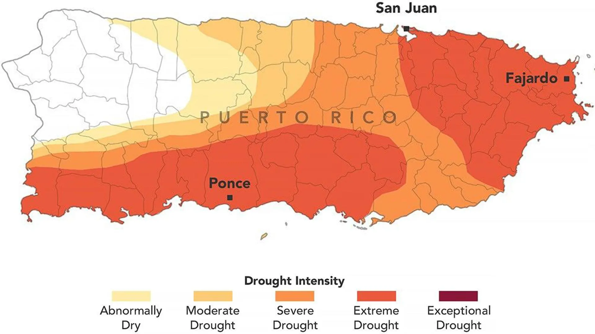
The Puerto Rico drought map for August 25, 2026 shows the severity and geographic extent of drought across the territory. The map was produced by the U.S. Drought Monitor, a collaborative initiative involving the National Drought Mitigation Center at the University of Nebraska–Lincoln, the U.S. Department of Agriculture (USDA), the National Oceanic and Atmospheric Administration (NOAA), and NASA.
NASA has supported the U.S. Drought Monitor for many years through Earth-observation data and scientific expertise. In 2026, NASA’s involvement expanded when two agency scientists joined the small team responsible for producing weekly drought assessments.
David Mocco, principal investigator at NASA’s Goddard Space Flight Center Hydrology Laboratory, said the effects of Puerto Rico’s unusually hot and dry weather are visible in satellite observations and ground-based data used by the U.S. Drought Monitor.
Recent assessments of Puerto Rico incorporate satellite-based soil-moisture estimates, weather observations, river-flow measurements, and data on groundwater and well conditions, Mocco said.
Mocco prepared the August 18, 2026, U.S. Drought Monitor update. He and Jonathan Case of NASA’s Marshall Space Flight Center were the first NASA scientists to produce the weekly drought maps.
Extreme drought covers 44% of Puerto Rico
As of August 25, approximately three-quarters of Puerto Rico was experiencing at least moderate drought, according to the latest assessment. The extreme drought zone, shown in dark orange, expanded across eastern and southwestern parts of the main island during the previous week and covered 44% of the territory.
The change occurred quickly. Just three months earlier, no part of Puerto Rico was classified as being in drought, while less than 20% of the territory was considered abnormally dry.
According to a National Integrated Drought Information System (NIDIS) report, late winter and early spring were wetter than normal across the U.S. Caribbean. Conditions then shifted rapidly toward persistent dryness.
Puerto Rico rainfall expected to remain well below normal
From mid-May through mid-July, much of Puerto Rico received less than 60% of its normal precipitation, according to NIDIS. Southern and southwestern areas were even drier, recording less than 20% of normal rainfall. The resulting precipitation deficit reached approximately 3 to 6 inches (76 to 152 millimeters).
High temperatures intensified the drying. San Juan, for example, experienced one of its hottest Julys on record. River levels also dropped sharply, with waterways such as the Río Fajardo in northeastern Puerto Rico reaching record lows.
Water shortages affect residents, farmers, and ranchers
Water shortages are affecting communities, farmers, and ranchers throughout Puerto Rico. According to the government, water rationing has been implemented in several municipalities since early August, according to news reports. Observers also say aging and inadequate infrastructure is worsening the impact of the drought.
The drought is creating serious challenges for Puerto Rico’s agricultural sector. Dry soil can stunt the growth of fruit, cacao, banana, and coffee trees, increasing the risk of crop losses. Ranchers are also facing declining hay supplies for livestock.
Drought maps help guide emergency response
Published since 1999, the U.S. Drought Monitor map helps federal, state, local, and tribal authorities make decisions about drought response and emergency assistance.
The U.S. Department of Agriculture uses the maps as part of its “fast-track” process for issuing disaster designations. These designations can help deliver emergency assistance, financial support, and other resources to communities affected by drought.
Source: www.sciencedaily.com