


A Massive Greenland Iceberg Drifts Into the Denmark Strait
Greenland’s rugged coastline is bordered by deep fjords, many of which are home to glaciers that flow directly into the ocean. When these glaciers calve, they release icebergs that drift through Greenland’s fjords and surrounding waters. In June 2026, satellite imagery captured an unusually large iceberg more than 1,000 kilometers south of its likely origin in northeastern Greenland.
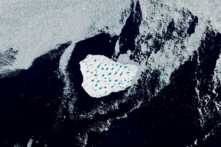
The images were collected by the Operational Land Imager (OLI) aboard NASA’s Landsat 9 satellite on June 12, 2026. They show the iceberg drifting through the Denmark Strait, the stretch of ocean between Greenland and Iceland. The bright-white iceberg was surrounded by sea ice and broken ice fragments known as melange, just south of Kangikajip Aparia, a headland on Greenland’s eastern coast visible in the upper-left portion of the image.
Alexis Denton, an oceanographer and chief scientist with the International Glacier Patrol, said several characteristics confirm that the feature is an iceberg rather than a section of thick, multiyear sea ice. Its location near the Greenland coast, bright color, and significantly larger size than the surrounding sea ice all point to its glacial origin.
On June 12, the iceberg covered approximately 17 square kilometers (7 square miles)—about five times the size of New York City’s Central Park. Although the iceberg is relatively small compared with the enormous icebergs produced by Antarctic ice shelves, it is exceptionally large by Greenlandic standards.
Kjeld Quistgaard, a senior ice adviser at the Danish Meteorological Institute, identified Jökelbugten in northeastern Greenland as the iceberg’s likely source region. However, its precise origin within the bay remains uncertain. Scientists believe it may have calved from the Zachariae Isstrøm glacier or from a remnant ice shelf nearby.
The ice shelf that once filled the bay alongside Zachariae Isstrøm began breaking apart after the glacier retreated rapidly in the early 2000s. Since then, pieces of the former ice shelf may have remained trapped among islands and coastal ice, making it difficult to trace the iceberg’s journey using satellite imagery alone.
During spring, sea ice and glacial debris cover much of the bay and nearby coastline. Individual icebergs can be difficult to identify, especially when they are coated with snow. In late May, the iceberg was surrounded by many similar ice formations. As summer progressed and the surrounding sea ice thinned, the large iceberg became easier to distinguish.
Its size and distinctive pattern of blue meltwater ponds also provide clues about its origin, according to Christopher Shuman, a retired glaciologist at the University of Maryland. Shuman said the iceberg may have broken away from a remnant ice shelf rather than calving directly from the glacier itself.
Icebergs produced by Zachariae Isstrøm are typically smaller, he noted. The iceberg’s surface is covered with numerous blue “Swiss cheese” meltwater ponds, a feature commonly associated with old ice-shelf fragments. Historical satellite images also show sections of the former ice shelf drifting south and becoming trapped between islands bordering the bay, where winds and ocean currents may have kept them in place for years.
By mid-August, the iceberg had traveled approximately 1,500 kilometers (900 miles) from its source region. It was moving south along Greenland’s coast with the Greenland Coastal Current before entering the North Atlantic Ocean. Quistgaard predicted that the iceberg would continue breaking apart during August, and recent satellite imagery suggests that fragmentation is underway.
Because the iceberg is breaking apart in the Denmark Strait, its remains are unlikely to reach the busy shipping routes near southern Greenland. Even so, its long journey highlights the constantly changing nature of Greenland’s glaciers, sea ice, ocean currents, and climate in the North Atlantic.
NASA Earth Observatory image by Lauren Dauphin, using Landsat data from the United States Geological Survey. Story by Kathryn Hansen.
- NASA Earth Observatory. “Zachariae Isstrøm Glacier, Greenland.” December 4, 2015. Accessed August 19, 2026.
- Sutherland, D. A., and Pickart, R. S. (2008). East Greenland Coastal Current: Structure, Variability, and Flow. Progress in Oceanography, 78(1), 58–77.
Source: science.nasa.gov