


Autumn leaf viewing has a long cultural history, but today satellites are giving scientists a global view of the seasonal change. NASA’s PACE satellite uses hyperspectral observations to track the pigments that produce red, yellow, orange and green vegetation, revealing when autumn color emerges, reaches its peak and fades. The data may also help researchers study drought, insect damage, plant disease, wildfire risk and the role of vegetation in the global carbon cycle.
From momijigari to satellite observations
The Japanese tradition of momijigari, or “red leaf picking,” dates back more than 1,000 years, according to ancient texts and poetry. In the United States, autumn foliage excursions began appearing in historical records in the 19th century. Artists and poets including Frederic Church and Emily Dickinson helped celebrate the colors of the season.
Modern leaf peepers have new ways to follow this seasonal phenomenon. NASA’s PACE satellite—short for Plankton, Aerosol, Cloud, ocean Ecosystem—carries the hyperspectral Ocean Color Instrument, or OCI. Although PACE was designed primarily to study Earth’s oceans and atmosphere, OCI also observes vegetation across the planet.
OCI measures light across 286 spectral bands. These wavelength groups allow scientists to detect subtle changes in the pigments found in leaves, including anthocyanins, which produce red tones; carotenoids, which produce yellow and orange tones; and chlorophyll, which produces green.
Mapping the spread of fall color
NASA scientists can track autumn color by measuring the amount of red, orange and yellow vegetation relative to green vegetation. Following that ratio over time shows where leaves are changing and when color reaches its peak.
The maps show vegetation “redness” from September 29 to October 4, 2026, on the left, and from October 5 to October 11, 2026, on the right. Areas shown in green have values close to 1, meaning the satellite detects about as much red as green and most leaves have not yet changed color. Light yellow and red areas have higher values, indicating progressively more red pigment relative to green.

The satellite detected particularly high levels of redness in parts of northern and eastern Russia, northern Alaska and northern Canada between September 29 and October 4. During the week of October 5 to 11, redness began to fade in New England and upstate New York while spreading across much of the Midwest and mid-Atlantic.
Not every yellow or red area on the maps represents autumn foliage. In some agricultural regions, anthocyanin levels rise as crops ripen and after harvest. Clouds can also create apparent gaps in the vegetation data.
Which plants produce the strongest reds?
Many of the reddest regions—including New York’s Adirondack Mountains, Vermont’s Green Mountains and New Hampshire’s White Mountains—contain large numbers of sugar maples and red maples (Acer rubrum), deciduous trees that can turn vivid crimson in autumn.
In the wet tundra of northern Alaska, Canada and Russia, blueberries, bilberries, sedges, mosses and grasses may be responsible for the intense red colors detected by the satellite.
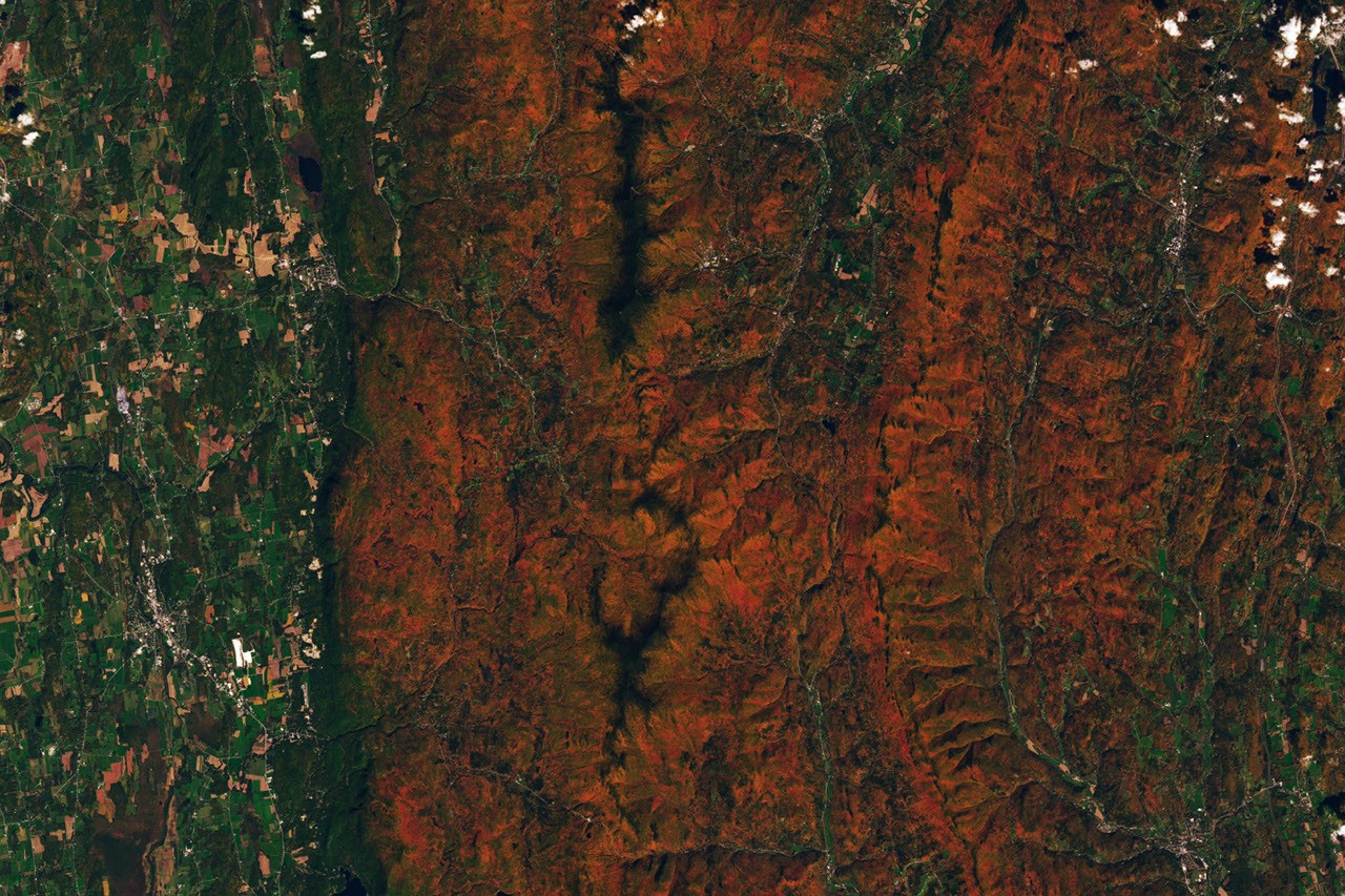
NASA’s Landsat 9 also captured bright red fall foliage near Ripton, Vermont, on October 3, 2026, around the area’s peak color. The satellite used its Operational Land Imager, or OLI.

Poet Robert Frost, whose works include “October”, “The Road Not Taken” and “Nothing Gold Can Stay”, had a summer home and farm in Ripton and taught at the Bread Loaf English School in Middlebury.
PACE’s global view
Other satellites carry hyperspectral sensors that can measure leaf pigments in a way similar to PACE, but generally over more localized areas and less frequently. PACE is the first satellite able to measure all three major leaf pigments—anthocyanins, carotenoids and chlorophyll—across the globe every one to two days.
“The ability to repeatedly collect time-series data on anthocyanins and carotenoids anywhere on the planet is game-changing,” said Karl Huemmrich, a vegetation scientist at the University of Maryland, Baltimore County’s Goddard Earth Science and Technology Research II Center. Huemmrich is also a member of the PACE science team.
He said he was enthusiastic about working with OCI because of its broad coverage and short revisit time. “The time series data allows us to determine peak redness and yellowness anywhere on Earth,” he said.
Why leaves change color
In autumn, leaves age and change color as levels of chlorophyll decline. Chlorophyll is the green molecule plants use to produce food. Because it is not stable, plants must continually synthesize it, a process that requires sufficient sunlight and warm temperatures.
As days become shorter and temperatures cool, chlorophyll production falls and the green color fades. Carotenoids and anthocyanins then become more visible, producing yellow, orange and red shades.
Ground observations can improve satellite data
As part of the North American Phenology Campaign, operated through the Global Learning and Observations to Benefit the Environment (GLOBE) Program, NASA data scientist Skye Caplan has posted a weekly autumn leaves map showing vegetation redness.
The map shows a red wave emerging at high latitudes in August and moving toward the equator in September and October. The PACE team is asking the public to submit photographs of fall foliage so scientists can compare ground observations with satellite measurements and better understand the factors that affect vegetation color.
“Pigment changes can also occur when vegetation is stressed by drought or insect damage,” Caplan said. He noted that these changes likely help explain why PACE measures higher redness in agricultural regions of Brazil, Australia and Canada that do not closely follow broad seasonal patterns.
“The more pictures we can get from the ground, the better,” Caplan said. Ground-based photographs will help scientists improve PACE’s observations of vegetation color and could support research into spring green-up, autumn senescence, vegetation’s effect on the global carbon cycle and the relationship between leaf color and wildfire risk.
Scientists also want to determine whether PACE can detect early warning signs of drought, insect infestation and plant disease.
People who live in areas without deep forests or dramatic fall foliage can still participate in the GLOBE campaign. Scientists are also seeking observations of shrubs, grasses, wildflowers, evergreens, crops and other vegetation. For those watching autumn color, Caplan offered a reminder: “The color change happens slowly, then all at once, and then disappears.”
NASA Earth Observatory image by Lauren Dauphin, used with PACE data. Data provided by Skye Caplan, NASA’s Goddard Space Flight Center, and the U.S. Geological Survey. Photograph courtesy of the GLOBE Program. Story by Adam Voiland.
Sources
- Caplan, S. & Huemmrich, F. (2025), “PACE OCI launches hyperspectral terrestrial data product”, Remote Sensing Letters 16(4), 422–433.
- GLOBE Program (October 18, 2026), “PACE: Latest information on autumn leaves”. Accessed October 22, 2026.
- GLOBE Program (2026), “North American Phenology Campaign”. Accessed October 22, 2026.
- GLOBE Program (September 22, 2026), “Track fall colors with PACE”. Accessed October 22, 2026.
- Huemmrich, K. et al. (2026), “Observing autumn leaves with PACE pigment index”, Remote Sensing Letters 17(6), 853–863.
- Mental Floss (August 20, 2024), “History of leaf peeping”. Accessed October 22, 2026.
- NASA Science Visualization Studio (2025), “PACE: A global perspective on terrestrial vegetation data”. Accessed October 22, 2026.
- UMBC (June 12, 2026), “For leaf peepers: How NASA’s PACE is improving fall foliage predictions”. Accessed October 22, 2026.
- Beltra (2025), “Autumn in Japan: The cultural meaning of autumn leaves and autumn foliage viewing”. Accessed October 22, 2026.
Source: science.nasa.gov