


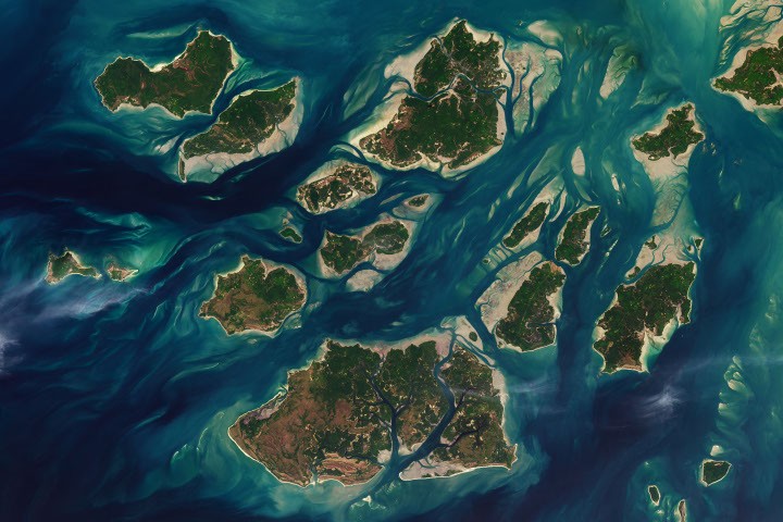
Twice a day, the tide rises and falls through a labyrinth of sandy channels, tidal flats, and lush mangrove forests surrounding the captivating Bijagos Islands (Arquipélago dos Bijagós in Portuguese). This dynamic tidal process dramatically alters the landscape, revealing the intertidal zone. Sandy beaches and tidal flats emerge from the ocean, forming new islands that expand and contract within hours.
The relentless rhythm of the tides sustains a rich array of marine life in the archipelago, which, as of 2025, is recognized as a UNESCO World Heritage Site. This designation honors the unique active delta archipelago along Africa’s Atlantic coast, where the interplay of tides, river sediments, coastal upwelling, and currents creates a highly productive and biodiverse ecosystem.
According to UNESCO, the islands host approximately 870,000 migratory sandpipers, making it one of West Africa’s most crucial bird feeding grounds along the East Atlantic Flyway. Numerous bird species thrive on the rich mix of marine insects, crustaceans, mollusks, and small fish found in the mudflats exposed at low tide. During high tide, manatees, dolphins, and fish congregate near the islands before retreating deeper into the ocean, while mangrove forests shelter thousands of sea turtles that swim ashore in search of nesting sites.
A significant population of green sea turtles nest on the tiny Poilan Island within the João Vieira and Poilão Marine National Park. Following hatching, young turtles must navigate a perilous route to the sea by night, evading numerous predators such as crabs, lizards, and birds. In the water, baby sea turtles confront additional threats, including horse mackerel, barracuda, grouper, snapper, tuna, mackerel, sharks, and rays. Alarmingly, estimates suggest that less than 1 percent of green sea turtle hatchlings survive to adulthood.
A recent 2025 analysis examined the region’s tides, revealing why the Bijagos Islands have the largest tidal range in West Africa. Researchers found that the region’s expansive, shallow shelves and unique estuary geometry create tidal variations of up to 7 meters (23 feet), compared to around 1 meter (3 feet) in other parts of the West African coast. Scientists are utilizing NASA/CNES TOPEX/Poseidon, Jason-1, and Jason-2 satellites to verify survey findings.
NASA Earth Observatory image by Lauren Dauphin, utilizing Landsat data from the United States Geological Survey. Narrated by Adam Voiland.
- Campredon, P. & Catley, P. (2016) The Bijagos Islands (Guinea-Bissau) in “The Book of Wetlands”. (Springer, Dordrecht).
- Die, A. & Others. (2025) Tidal Amplification and Distortion in Guinea-Bissau, West Africa. Estuary, Coast and Shelf Science, 320; 109318.
- Hayes, G. & Others. (2026) Is it really true that only 1 in 1,000 baby sea turtles survives to adulthood?? Royal Society Open Science 13(1), 251563.
- The New York Times (April 22, 2024) Thousands of turtles gather on a remote island every year. Will it be able to attract tourists?? Accessed July 16, 2026.
- Oceanus (January 30, 2025) How are we supposed to count them all?? Accessed July 16, 2026.
- UNESCO (2025) Coastal and Marine Ecosystems of the Bijagos Islands – Omati Minho. Accessed July 16, 2026.
This version enhances SEO by using relevant keywords and phrases while maintaining the original HTML structure and content.
Source: science.nasa.gov