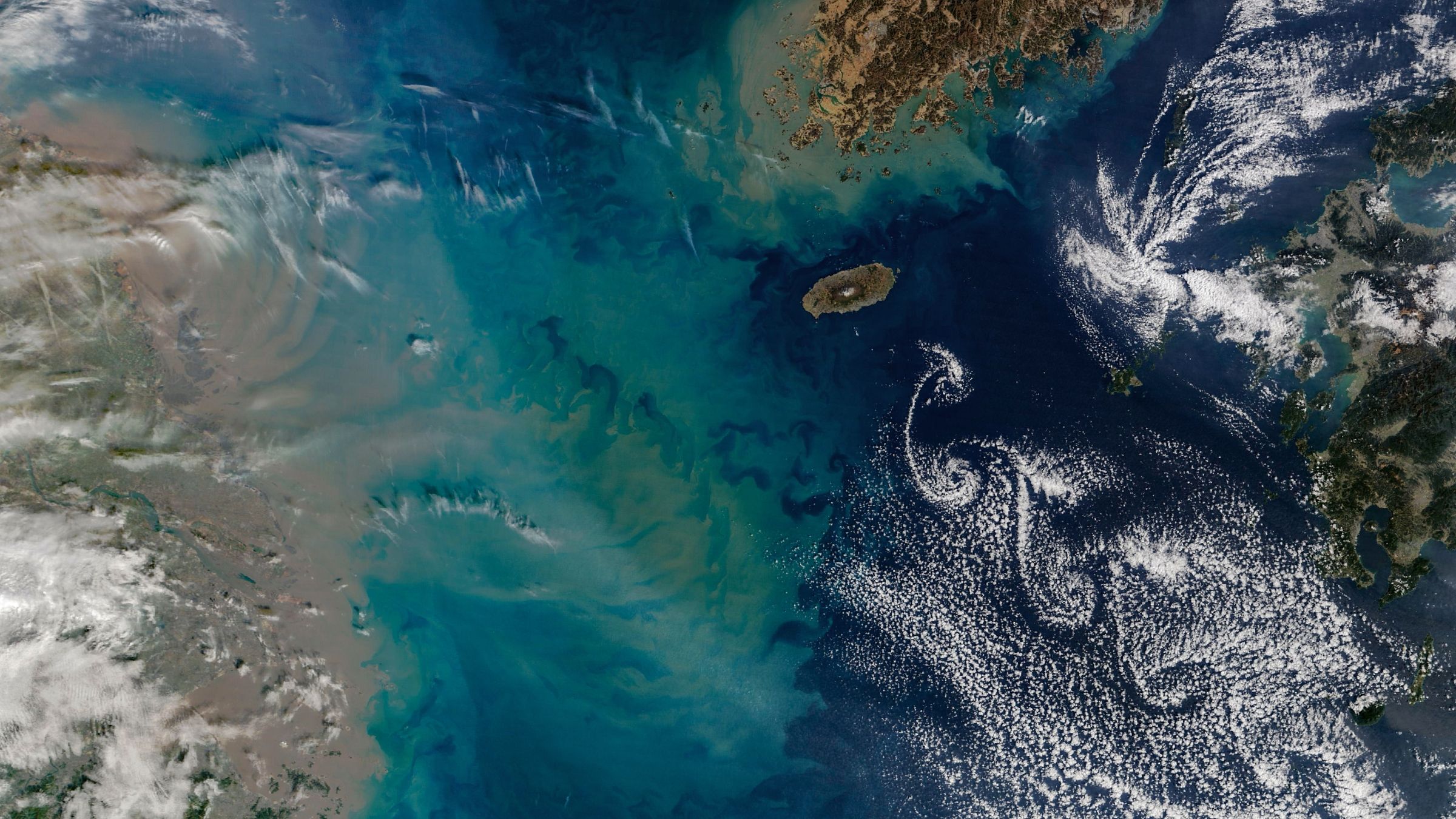
What is in the photo? A cloud “street” swirling beside a large, multicolored sediment plume
Which satellite took the photo? NASA’s Terra satellite, using the Moderate Resolution Imaging Spectroradiometer (MODIS)
When was the photo taken? February 19, 2026
A striking satellite image shows a swirling “street” of clouds beside a vast multicolored sediment plume in the waters between China, South Korea and Japan.
The cloud formation is a Von Kármán vortex street — a series of rotating air currents created when strong winds flow around a large obstacle. In this case, the obstacle is Hallasan, a 1,950-meter (6,400-foot) shield volcano at the center of South Korea’s oval-shaped Jeju Island.
Jeju Island lies approximately 60 miles (100 kilometers) south of the Korean Peninsula in the East China Sea. China’s Jiangsu province appears to the left of the image, while Japan’s Kyushu Island is visible to the right.
How the cloud vortex formed
When winds reach approximately 11 to 34 mph (18 to 55 km/h), they can split and flow around the island’s mountainous peak. As the air moves downstream, it forms alternating counter-rotating vortices. These vortices can shape nearby clouds into long, repeating spirals.
According to NASA Earth Observatory, the three largest cloud spirals in the image stretch for roughly 230 miles (370 kilometers) from end to end.
A giant sediment plume flows from China’s coast
The satellite view also captures a broad brownish curtain of sediment spreading through coastal waters along eastern China, including the area near Shanghai. Much of this material is carried into the sea by the Yangtze River, the third-longest river system on Earth.
A more colorful yellow-and-green sediment plume extends approximately 270 miles (430 km) offshore. The plume appears to approach the Von Kármán cloud vortex, creating an unusually dramatic juxtaposition of atmospheric and oceanic patterns.
South Korea’s Jeju Island is home to Hallasan, the country’s highest peak and a shield volcano rising 6,400 feet above the East China Sea.
(Image credit: NASA/Landsat/Robert Simmon, via Wikimedia)
Why the sediment plume is so colorful
The elongated blue-white and brownish plumes are likely linked to increased winter rainfall in the Yangtze River basin, stronger seasonal ocean currents and vertical mixing in the coastal ocean. These processes can transport and spread river sediment across hundreds of miles of sea.
Von Kármán vortex streets are frequently visible near mountainous islands, including Guadalupe Island in Mexico and several of the Canary Islands. Sediment plumes are also regularly observed from space. However, seeing a large atmospheric vortex develop immediately beside an extensive ocean sediment plume is comparatively rare.
Get the world’s most fascinating discoveries delivered straight to your inbox.
Jeju Island’s volcanic history
Jeju Island formed after undersea volcanic eruptions beginning approximately 2 million years ago. The island has been inhabited by Indigenous Jeju Islanders for thousands of years and is known for its distinctive culture, rugged coastline and haenyeo — traditional female divers who free-dive for seafood in the island’s cold coastal waters.
Hallasan: South Korea’s highest mountain
Hallasan, also known as Mount Halla, is the highest mountain in South Korea. Although it is classified as an active volcano, Hallasan has not erupted since 1007 A.D., according to the Smithsonian Institution’s Global Volcanism Program.
The volcano is also famous for its extensive network of underground lava tubes. Several of Jeju Island’s volcanic features are recognized as part of a UNESCO World Heritage site, including the island’s lava tube systems and volcanic landscapes.
UNESCO recognizes Jeju’s volcanic formations as an important example of volcanic landforms and geological processes.