


Rare, Widespread Snow Blankets Chile’s Atacama Desert in August 2026
A series of powerful winter storms brought rare and unusually widespread snowfall to Chile’s Atacama Desert in August 2026. The storms covered parts of northern Chile with snow from the Andes Mountains to areas near the Pacific coast, transforming one of the driest places on Earth into a temporary winter landscape.
Snowfall has occurred in the Atacama Desert before, including notable events in 2025 and 2011. However, the August 2026 storms were exceptional because of their geographic extent. Snow and rain affected areas across the Andes, the desert’s extremely arid interior, coastal regions, and nearby parts of Bolivia, Argentina, and Peru.
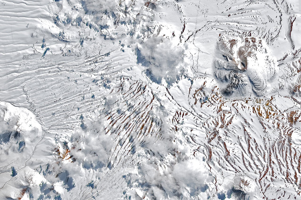
NASA satellite images reveal snow at the Chajnantor Plateau
The Operational Land Imager (OLI) aboard the NASA-USGS Landsat 8 and Landsat 9 satellites captured images of the Chajnantor Plateau on August 6 and August 14, 2026. The plateau is part of the Altiplano-Puna Volcanic Complex and is home to the Atacama Large Millimeter/submillimeter Array, widely known as ALMA.
ALMA is one of the world’s most powerful radio observatories. Heavy snow and wind during the storm forced the facility to suspend observations and move its antennas into protective survival mode.
Snow spread from the Andes to the Pacific coast
A second storm later in August produced even more widespread snowfall. An image captured by the Moderate Resolution Imaging Spectroradiometer (MODIS) aboard NASA’s Terra satellite on August 19 shows snow extending westward from the Andes across the heart of the Atacama Desert.
The snow reached areas close to the Pacific coast south of the Chilean port city of Antofagasta. Several astronomical observatories in the region also suspended operations during the severe weather.
What caused the unusual Atacama snowfall?
Winter precipitation in northern Chile is often linked to a cutoff low—a low-pressure system that separates from the jet stream and moves into the region. Atmospheric scientist René Garreau of the University of Chile said a cutoff low also contributed to the major snowfall event in 2025.
The late-August 2026 storm developed from an unusually large atmospheric trough, a long and narrow zone of relatively low pressure. The trough extended across a broad section of the Southern Hemisphere, from the southern tip of South America toward the subtropics.
Strong atmospheric instability and abundant moisture along the coast helped spread precipitation across an unusually large area. Snow and rain fell offshore, along the coast, throughout the central Atacama Desert, and across the Andes. Garreau described the event as occurring on “a scale rarely seen in extremely arid regions.”
Heavy rain triggered flooding and debris flows
Not all of the precipitation fell as snow. In lower-elevation coastal areas, rain produced significant rainfall totals. Taltal, on Chile’s northern coast, received nearly 40 millimeters of rain over three days—approximately 10 times its annual average, according to Garreau.
“We only see this kind of event a few times a decade, if ever,” he said.
The intense precipitation also caused debris flows and flash floods in parts of northern Chile. The National Disaster Prevention and Response Agency (SENAPRED) reported that thousands of people were affected and hundreds of homes sustained severe damage.
El Niño contributed to a wetter-than-usual winter
Garreau linked the unusually wet winter in north-central Chile to the strengthening El Niño climate pattern. In addition to the August snowfall, a major storm in July 2026 affected Chile’s Norte Chico region.
During El Niño conditions, blocking high-pressure systems can develop in the South Pacific near the southern tip of South America. At the same time, the subtropical Pacific high-pressure system that normally helps keep northern Chile dry may weaken. Together, these changes can shift Southern Hemisphere storm tracks closer to the equator, increasing the likelihood of unusual winter precipitation in northern Chile.
NASA Earth Observatory images by Lauren Dauphin, using Landsat data from the United States Geological Survey and MODIS data from NASA’s LANCE and GIBS/Worldview. Story by Kathryn Hansen.
August 6, 2026: Landsat 8
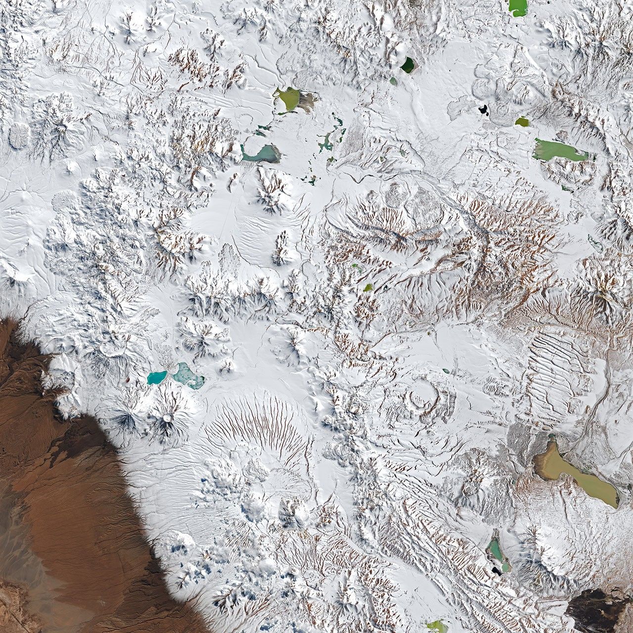
August 14, 2026: Landsat 9
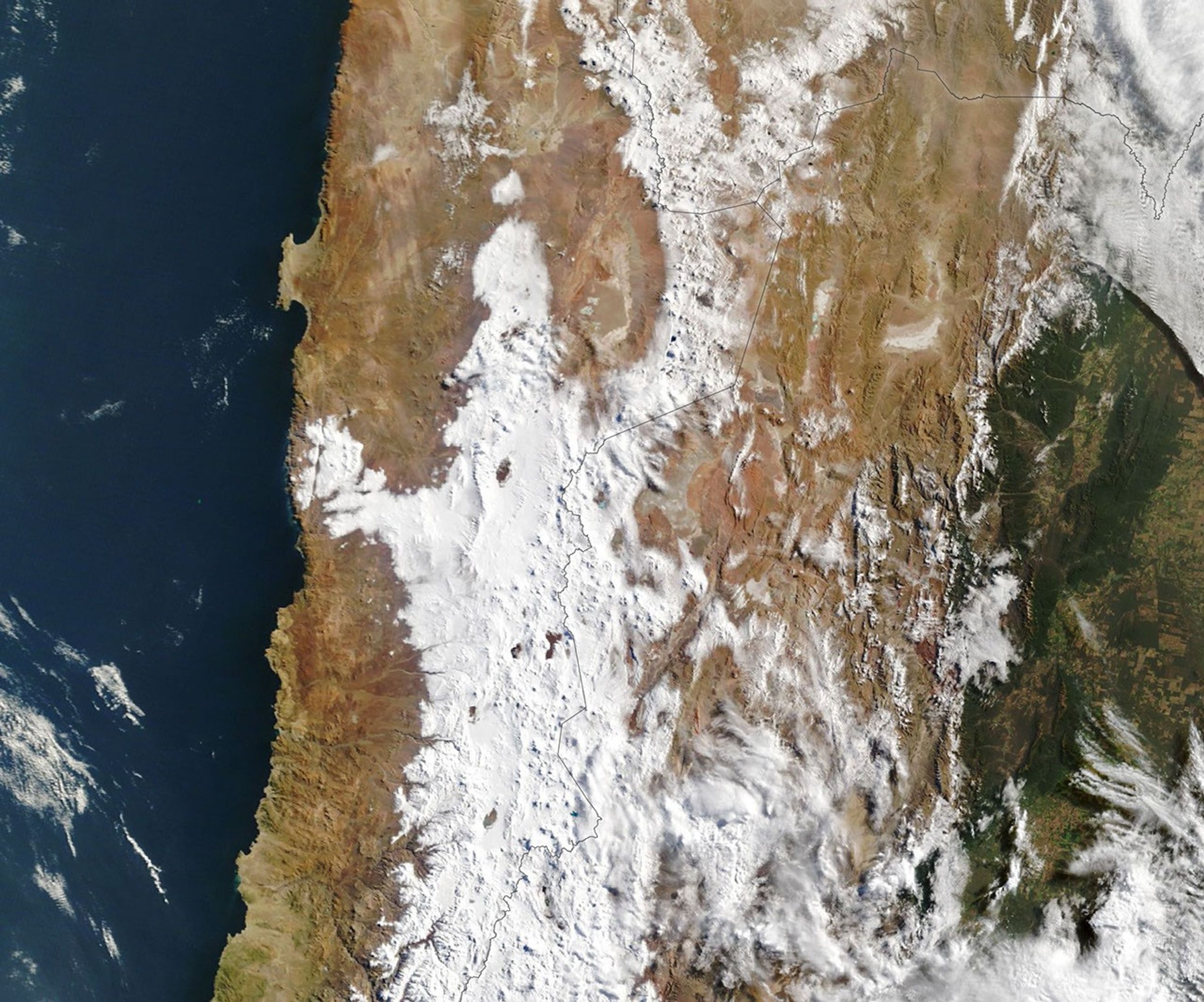
August 19, 2026: Terra MODIS
Sources
- CR2 (July 23, 2026), “Extreme Events from 15 to 20 July 2026 in the Ongoing El Niño Situation.” Accessed August 26, 2026.
- NASA Earth Observatory (July 19, 2025), “Unusual Snowfall in the Atacama Desert.” Accessed August 26, 2026.
- National Weather Service Climate Prediction Center (August 13, 2026), “Discussion on Diagnosis of El Niño/Southern Oscillation (ENSO).” Accessed August 26, 2026.
- Watchers (August 18, 2026), “ALMA Observations Suspended in Chile’s Atacama Desert Due to Snow and 90 km/h Winds.” Accessed August 26, 2026.
Source: science.nasa.gov