


Antarctic Sea Ice Reaches Its 2026 Maximum: What Satellite Data Shows
This story updates the Antarctic sea ice feature in NASA’s World of Change series, which uses satellite imagery to track long-term changes on Earth’s surface.
Why Antarctic sea ice expands and retreats
Unlike the Arctic, which is an ocean surrounded by land, Antarctica is a continent surrounded by ocean. This geography allows Antarctic sea ice to spread across a larger area during the Southern Hemisphere’s winter. However, because the ice extends into warmer latitudes, it is also more vulnerable to melting during summer.
Antarctic sea ice typically reaches its annual maximum in September, near the end of winter, and retreats to its minimum in February.
Antarctic sea ice maximum in 2026
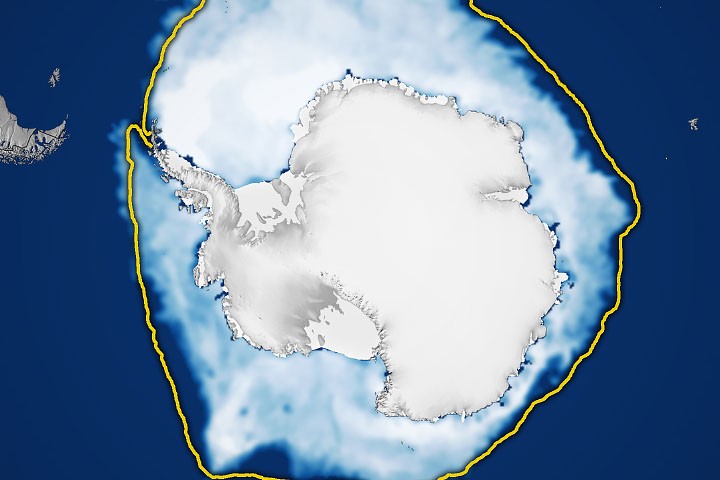
According to NASA and the National Snow and Ice Data Center (NSIDC), Antarctic sea ice most likely reached its 2026 maximum on September 14. On that date, sea ice covered an estimated 17.59 million square kilometers (6.79 million square miles), making it the third-smallest annual maximum in the satellite record.
NSIDC tracks Antarctic sea ice extent using satellite observations and reports the annual maximum after analyzing seasonal changes. The latest measurements provide another data point for scientists studying whether recent low ice levels reflect a long-term shift or natural year-to-year variability.
Antarctic sea ice extent from 1990 to 2026
The map below shows the average concentration of Antarctic sea ice in September, on the left, and February of the following year, on the right, from 1990 to 2026. Opaque white indicates the highest ice concentration, while dark blue represents open ocean.
The images include areas with ice concentrations of 15 percent or higher—the threshold scientists typically use to identify ice-covered regions in satellite data. The total area of these regions is called sea ice extent.
From 1979 to 2014, Antarctic sea ice extent increased by about 1 percent per decade. However, the significance of that increase remained uncertain because the extent varied widely from year to year. Satellites recorded record-high winter sea ice extent for three consecutive years, from 2012 through 2014, even as Arctic sea ice experienced a sharp decline.
Recent Antarctic sea ice decline
The increase ended in 2015, followed by a significant decline in Antarctic sea ice in 2016. Although some years have brought modest recoveries, Antarctic sea ice extent has remained substantially below average overall.
Both the record low and record high occurred in 2023. Scientists will continue monitoring Antarctic sea ice each year to determine whether the recent decline represents a long-term change or a statistical fluctuation.
How satellites measure sea ice
Scientists measure sea ice extent with satellites equipped with passive microwave sensors. These instruments detect the microwave energy naturally emitted by Earth’s surface. Sea ice emits more microwave energy than open water, allowing it to stand out in satellite imagery.
Because microwaves can pass through clouds, satellites can observe sea ice regularly regardless of weather conditions. This makes passive microwave data especially useful for tracking seasonal and long-term changes in polar sea ice.
A satellite record spanning nearly five decades
The Antarctic sea ice record began in late 1978 with data collected by NASA’s Nimbus-7 satellite. Defense Meteorological Satellite Program (DMSP) satellites followed in 1987. NASA’s Aqua satellite contributed observations from 2002 to 2011.
In 2025, scientists began using observations from the Japan Aerospace Exploration Agency’s GCOM-W satellite, following the transition described by the National Snow and Ice Data Center.
Image by Michala Garrison using data from NASA Earth Observatory and the National Snow and Ice Data Center.
Sources
- NASA Earth Data (October 2026), sea ice. Accessed October 8, 2026.
- NASA Earth Observatory (October 6, 2026), A World in Change: Antarctic Sea Ice. Accessed October 8, 2026.
- NASA Earth Observatory (September 16, 2016), Sea Ice. Accessed October 8, 2026.
- NASA Earth Science (September 23, 2026), Arctic Sea Ice Reaches Annual Minimum Extent in 2026. Accessed October 8, 2026.
- National Snow and Ice Data Center (September 23, 2026), Arctic Sea Ice Reached Its Minimum Extent in 2026. Antarctic Sea Ice Is Also Likely to Have Reached Its Maximum. Accessed October 8, 2026.
- National Snow and Ice Data Center (March 9, 2026), Antarctic Sea Ice Extent Reaches Near-Average Minimum. Accessed October 8, 2026.
Source: science.nasa.gov