


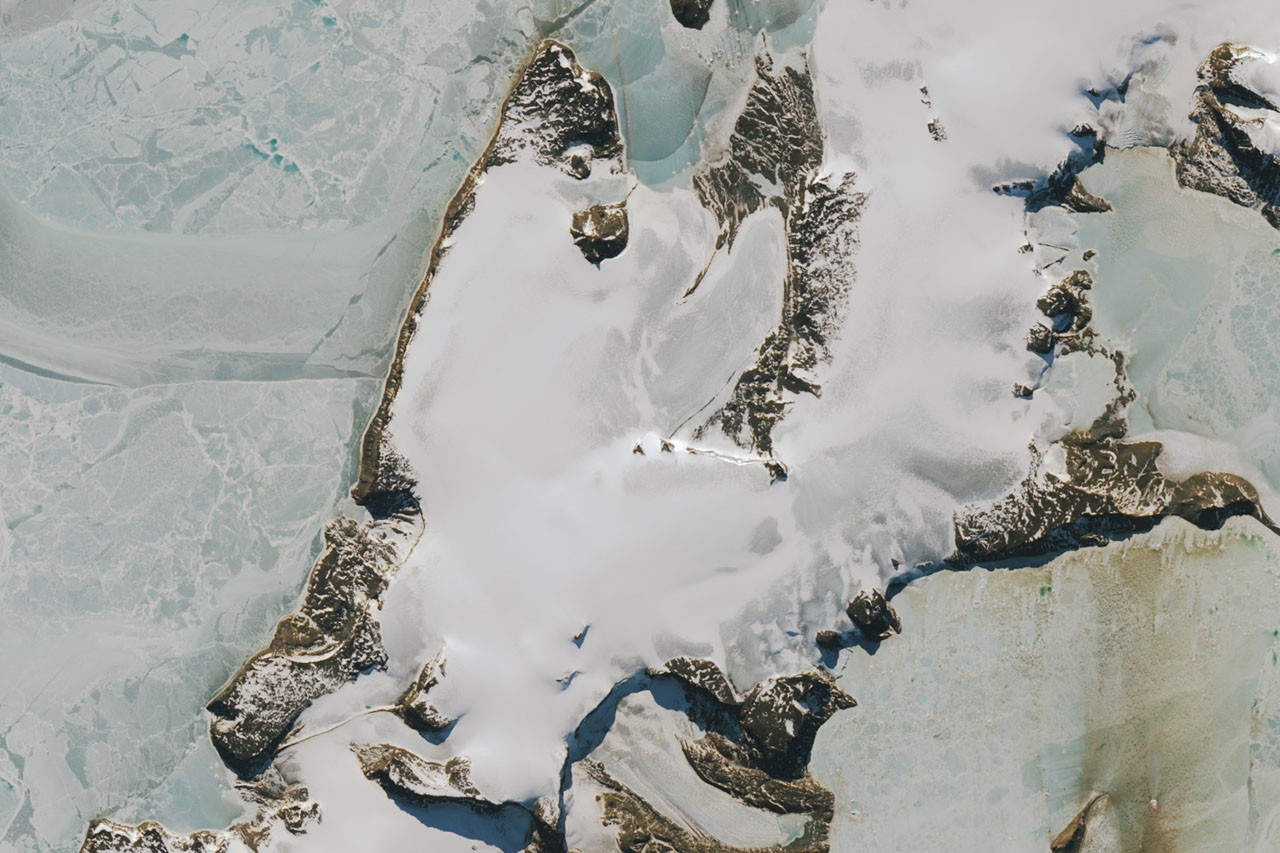
Vega Island, in the Weddell Sea east of the Antarctic Peninsula, appears to grin like a skull in satellite images. Rock outcrops resemble an eye socket, horizontal moraines form a mouth, and glaciers flowing from Bahia del Diablo (Devil’s Bay) create the impression of a jawbone. Images acquired by Landsat 9 show how the scene changed between March 2025 and October 2026, as seasonal snow gave way to darker, exposed ice.
A skull-shaped landscape
The images were captured by Landsat 9’s Operational Land Imager (OLI) on March 22, 2025, and October 10, 2026. Clouds covered the island in March 2026. The feature protruding from the ice is a nunatak, while a horizontal moraine forms the apparent mouth. Glaciers in Bahia del Diablo form the lower part of the skull-like profile.

In the March 2025 image, snow covers the ice, as is typical during the region’s wettest months. By October 2026, much of that snow had disappeared, leaving a darker ice surface.
Warm winter leaves bare ice exposed
Above-average winter temperatures in 2026, particularly in June, were partly responsible for the bare ice visible in October, according to Mauri Pelto, a glaciologist at Nichols College. Exposed ice on Vega and nearby islands indicates that little new snow accumulated during winter, while sublimation and wind-driven loss reduced the remaining snow further.
“Winter was not a special season for these glaciers,” Pelto said.
The coming thaw season could intensify the effect. Bare ice is darker than snow and absorbs more solar energy, so melting can accelerate as days become longer and warmer.
“Even a light layer of fresh snow from spring storms will help in the short term,” Pelto said. “If buried in snow or ice, the skull will be preserved. But if exposed to melt, it will weather, changing the jawline and enlarging the eye sockets.”
A long record of glacier change
Landsat imagery helped researchers produce the first comprehensive map of Vega Island’s ice. In a 1982 study, scientists described four ice sheets, protruding rock cliffs and glacier outlets. Using early Landsat observations together with aerial photographs and topographic maps, they catalogued 29 glaciers on the island.
Among them, Devil’s Bay Glacier has been closely monitored. Since the austral summer of 1998–1999, researchers have recorded an overall decline in its mass. Satellite imagery from recent decades indicates that other glaciers on the island are also losing ice, expanding the area of exposed bedrock.
A landmark in an Antarctic survival story
Long before scientists began monitoring Vega’s glaciers, the island featured in the history of Antarctic exploration. The Swedish Antarctic Expedition of 1901–1903 investigated the geography, geology, climate and wildlife of the eastern Antarctic Peninsula and surrounding areas.
During the expedition, the group split into three parties and became stranded at separate locations for the winter. The expedition also lost its ship to pack ice. Cape Welmette, on the “frame” of Vega Island’s skull-like profile, was the site of a reunion between two of the groups in spring 1903. An Argentine expedition later rescued the survivors.
NASA Earth Observatory image by Lauren Dauphin, using Landsat data from the United States Geological Survey. Story by Lindsay Dorman.
Sources
- Snow-free glacier surface on the Antarctic Peninsula October 2026, From a Glacier’s Perspective, October 24, 2026. Accessed October 28, 2026.
- Northwestern Vega Island, Antarctic Glacier Reserve, From a Glacier’s Perspective, January 22, 2012. Accessed October 28, 2026.
- Rabassa, J. et al. (1982), Antarctic Peninsula, James Ross and the Vega Islands Glacier Inventory, Journal of Glaciology 3, 260–264.
- Skvarca, P. et al. (2004), Mass balance of Bahia del Diablo Glacier, Vega Island, Antarctic Peninsula, Journal of Glaciology 39, 209–213.
- Otto Nordenskjöld, Antarctic. Accessed October 28, 2026.
- The best Antarctic survival story you’ve never heard, Antarctic, October 8, 2024. Accessed October 28, 2026.
- Bahia del Diablo Glacier, World Glacier Monitoring Service, 2025. Accessed October 28, 2026.
Source: science.nasa.gov