


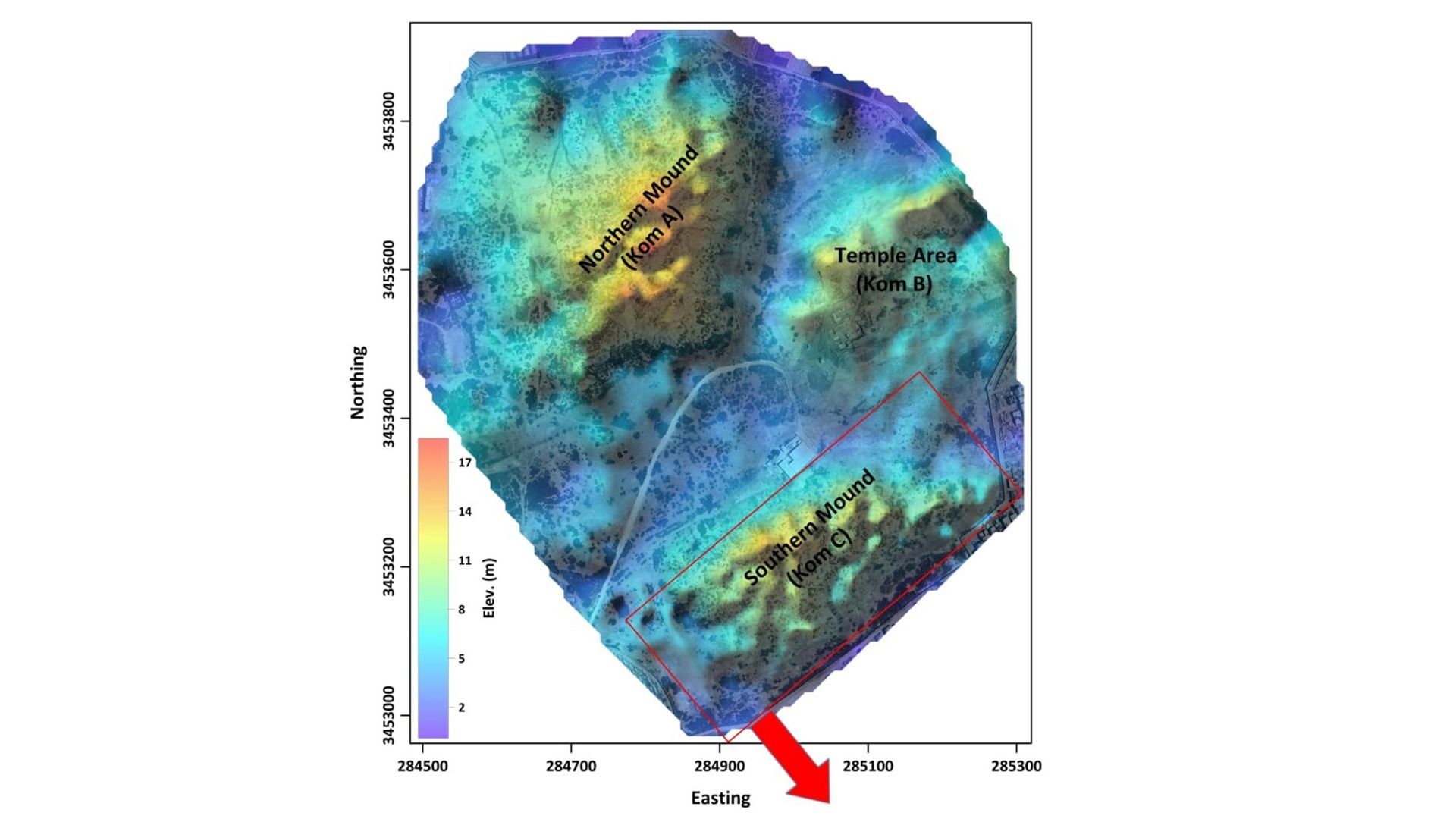
Egyptian researchers using satellite radar and electrical resistivity tomography have identified a hidden structure dating to Egypt’s 26th Dynasty beneath Tell el-Faran, the ancient settlement of Buto in the northwestern Nile Delta. The oval-shaped structure is about 420 feet (128 meters) long and 203 feet (62 meters) wide—roughly the size of a soccer field—and was built over a thick layer of clean sand that may have protected it from the delta’s unstable, waterlogged clay.
Mapping ancient Buto from above and below
Tell el-Faran is a large mound with a long, layered history. For ancient Egyptians, Buto was the sacred homeland of Wadjet, the cobra goddess of Lower Egypt, and one of the region’s most important religious centers. The site’s religious significance is documented in sources such as Cities of religious importance in the landscape of the pharaohs.
Archaeologists have excavated the mound’s upper layers for decades, uncovering remains from the Ptolemaic period, which lasted from 305 BC to 30 BC, and the Roman era, from 30 BC to 395 AD. Older layers were much harder to reach. A mound known as Kom C lies below the water table, surrounded by flooded delta clay, and earlier excavations had reached only the Ptolemaic and Roman layers before groundwater stopped them.
To investigate the deeper layers without extensively disturbing the site, the researchers first examined imagery from the European Space Agency’s Sentinel-1 satellite. The satellite generates radar images by sending microwave pulses toward Earth and measuring their reflections. Variations in surface moisture, elevation and reflectance can reveal indications of structures buried underground.
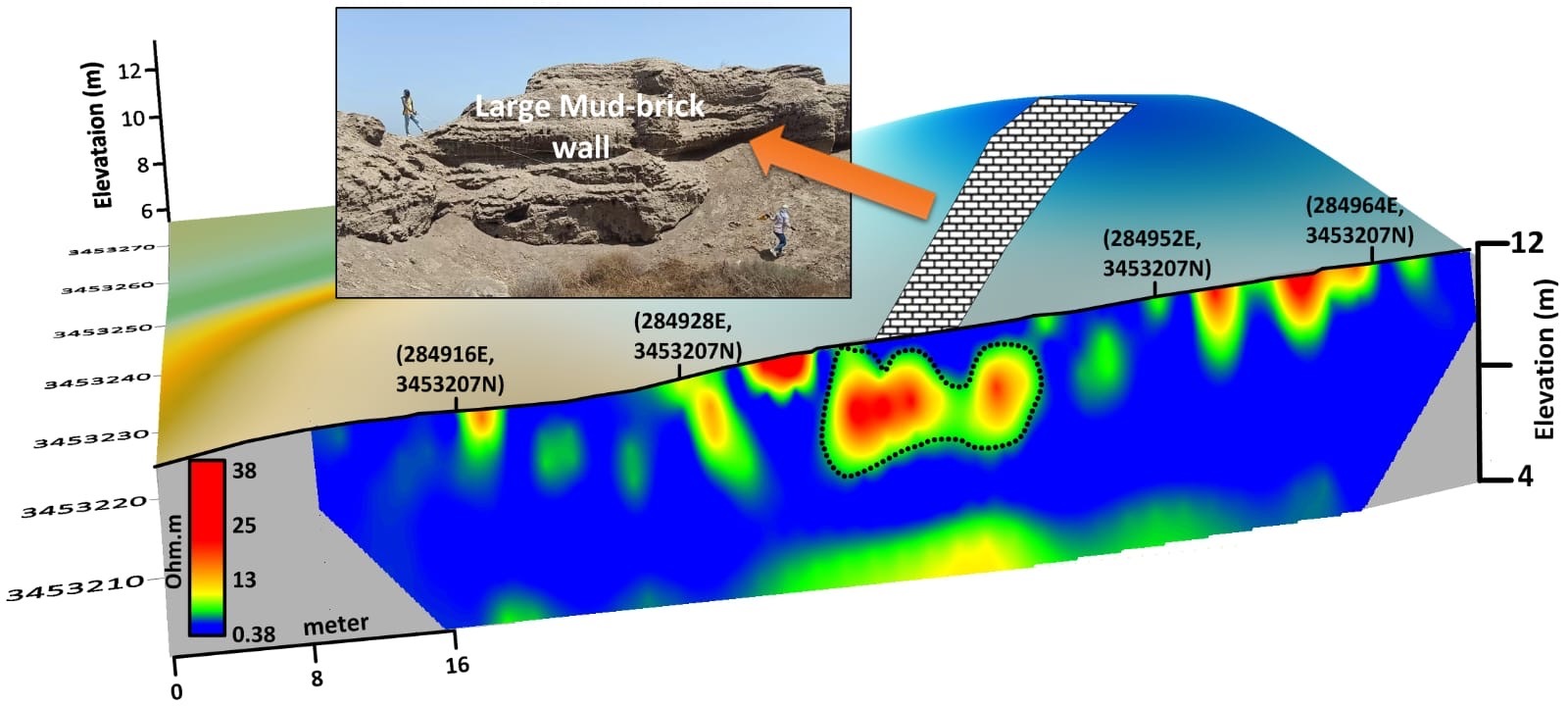
The radar data revealed a large oval-shaped anomaly beneath Kom C. The team then carried out electrical resistivity tomography, or ERT, along 15 parallel lines covering approximately 58,100 square feet (5,400 square meters). ERT sends electrical current through the ground and measures how it moves through different materials, allowing researchers to build a map of the subsurface.
Between the surface and a depth of 10 feet (3 meters), the researchers found material from the Ptolemaic and Roman periods, including dislodged mud bricks, pottery fragments and broken limestone. The debris suggests that the site was occupied and rebuilt repeatedly, with later residents demolishing older structures and reusing their materials.
A Saite-period structure
At depths of 10 to 20 feet (3 to 6 meters), the researchers detected a large adobe structure dating to the 26th Dynasty, also known as the Saite period, which lasted from 688 to 525 BC. The team assigned the date on the basis of the structure’s archaeological layers, the distinctive shape of its mud bricks and associated pottery. Carbon-14 dating applies to related organic materials.
The researchers said the building could have been a tomb, a priest’s house or a religious shrine. They described their findings in a study published in Acta Geophysica in 2026.
“By combining satellite radar and deep ERT profiles, we were able to not only map the walls of this massive Saite-era structure, but also analyze its subsurface layers,” Abdelaziz Elfadali, an associate research professor at Egypt’s National Remote Sensing and Space Science Agency, and his co-authors told Live Science. “The detection of a significant clean sand foundation layer beneath the adobe walls explains how these heavy structures withstood Buto’s high water table and shifting clay soils.”
At a depth of 20 to 23 feet (6 to 7 meters), the team unexpectedly found a thick, clean layer of sand beneath the structure. “The sand is a discovery within a discovery,” the researchers wrote.
Ancient engineering in unstable ground
The Nile Delta’s clay soils are difficult to build on because they absorb moisture and expand, then contract and shift as they dry. The researchers propose that the ancient builders packed clean sand beneath the building as a stabilizing layer. The sand would have distributed the structure’s weight, helped groundwater drain away from the foundation and reduced the movement of the underlying clay.
“Using pure sand as a stabilizing cushion was a brilliant and deliberate tactic. Ancient builders had a deep understanding of their environment.”
Hussein Bashir, director of the Alexandrina Library and Museum of Antiquities
“The layer of sand effectively acts as a barrier,” Elfadali said. “This prevents groundwater from penetrating upward into the adobe bricks, softening and dissolving them. The sand allows water to drain to the side instead of pooling at the foundation.”
Evidence of religious activity
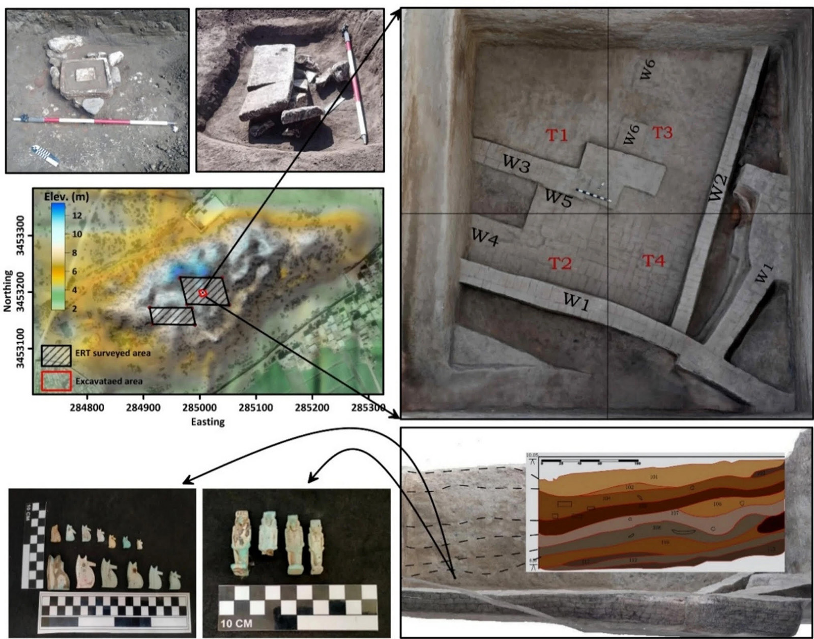
A 3 × 3-foot (10 × 10-meter) excavation trench, approximately 20 to 23 feet (6 to 7 meters) deep, exposed a thick mud-brick wall above the sand layer. Nearby materials suggested that the area may have had a sacred function.
The finds included ushabti and shawabti figurines—small servant statues commonly placed in graves to serve the deceased in the afterlife—and a limestone altar. The altar’s carved grooves contained dried residue consistent with animal blood, indicating that an offering ritual may have taken place there, Elfadali said. The study also reported rarer faience finds, including a baboon figurine associated with Thoth, the Egyptian god of wisdom.
A period of renewal
The Saite period was a time of cultural revival in Egypt. After reclaiming power from foreign rulers, the Egyptian pharaohs invested in restoring the country’s religious landscape, particularly in the Nile Delta, which had been their power base. Buto’s importance to Lower Egyptian identity made it a natural focus for this effort. The Saite kings ruled from the nearby delta city of Sais, so restoring Buto would have reinforced their connection to the region and their claim to the throne.
“A monumental building of this scale highlights the Saite pharaoh’s commitment to celebrating the Delta region,” said Hussein Bashir, director of the Museum of Antiquities at the Cultural Research Center, known as the Biblioteca Alexandrina. Bashir was not involved in the study and told Live Science in a WhatsApp message that the use of sand demonstrated the builders’ understanding of their environment.
The research team plans to return to the site with electrical resistivity surveys spaced farther apart so they can investigate deeper layers. Experts in ancient flora will also join the work to study how the landscape and its geological features changed over time. Their findings could help researchers reconstruct the environment around Buto when the newly identified walls were built.
The study is: Abu-Arab, MaR., Elfadaly, A., Elbehery, W., Wafa, O., Aboalkassim, I., Younes, A., Hiekl, AMA, Saada, SA, Wilson, P., and Ibrahim, A. (2026). “Multiscale detection of buried archaeological elements across different occupation stages: an integrated approach using radar satellite imagery and electrical resistivity tomography in Butu, northwestern Nile Delta, Egypt.” Acta Geophysica, 74(2).
For more on ancient Egypt, readers can also explore the Metropolitan Museum of Art’s overview of Egypt in the Late Period.
Source: www.livescience.com