


Why the Water of Rupert Bay Turns Beaver-Brown
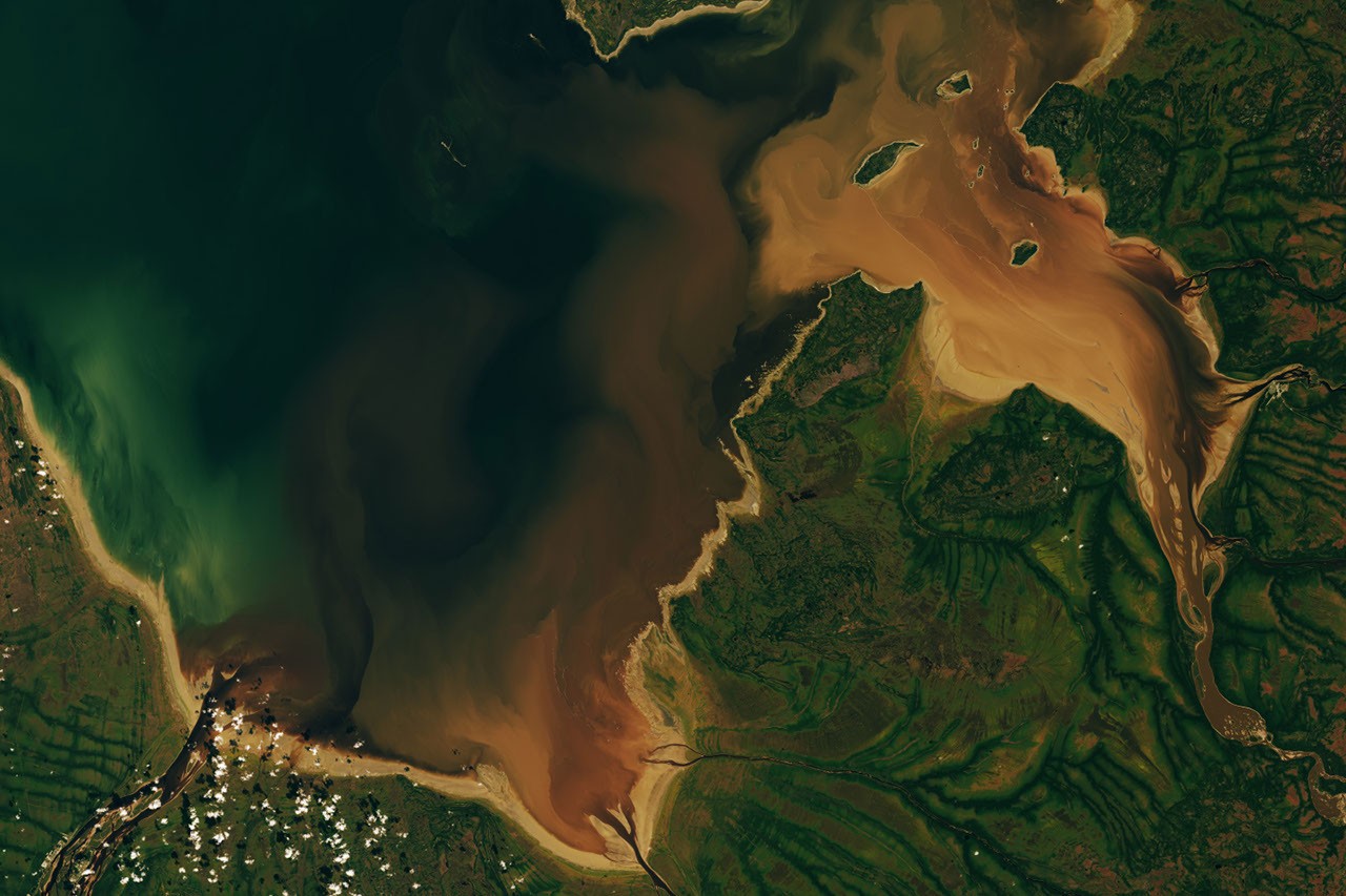
A Landsat 9 satellite image captured on September 27, 2026, shows dark brown river water flowing into Hanna Bay and Rupert Bay in Quebec, Canada. The color recalls the Southern East Cree word pataaunakun, meaning “the color of burnt beaver.” The distinctive hue comes from natural organic matter carried through the boreal forests, wetlands, rivers, and peatlands of the James Bay Lowlands.
What makes the water in James Bay brown?
The rivers and streams flowing into the two southernmost bays of James Bay wind through boreal forests and wetlands, often carrying brown-stained water. A major contributor is colored dissolved organic matter (CDOM), which absorbs blue and ultraviolet light in the electromagnetic spectrum.
CDOM includes organic compounds derived from tannins and lignin. These substances leach into rivers and streams as leaves, roots, bark, and soil break down. The same natural compounds help give brewed tea its familiar brown color. Humic substances are another important component of the organic material found in these waters.
Rivers, tides, and sediment shape the coastal colors
When Landsat 9’s Operational Land Imager captured the scene, the Moose, Nottaway, and Harricanaw Rivers were transporting brown water toward the broad tidal flats of Hanna Bay and Rupert Bay. There, the river water mixed with the deeper blue water of James Bay.
The light brown areas along the coast are tidal flats. They form in the shallow, gently sloping waters at the southern end of James Bay, where rivers continually deposit fine mud and other suspended sediment. Tides and river currents stir up the material, creating pale brown plumes that mix with the darker river water.
Post-glacial rebound is also slowly uplifting the landscape. Together, this gradual change and the steady delivery of sediment help build the low-lying coastal flats of the James Bay region.
Why the land appears green from space
The image also reveals patterns in moisture, vegetation, and drainage. Dense forests along the rivers appear dark green, while poorly drained peat bogs and other open wetlands appear lighter green because they support fewer trees.
Beavers in Cree history and mythology
Beavers have played an important role in the history, culture, and mythology of this lake-dotted region. Cree people have lived in the area for thousands of years and traditionally hunted beavers for meat and fur.
European merchants arrived at Rupert Bay in the 1660s in pursuit of beaver pelts. The Hudson’s Bay Company later established trading posts along the bay’s shores, helping expand the fur trade and making beaver an important part of the region’s economic history.
Beavers also appear in Cree stories connected to the landscape. One account, recorded by anthropologist Alanson Skinner, tells of a giant chasing a mythical giant beaver down the Nottaway River. The beaver escaped into Rupert Sound, while stones thrown by the giant missed the animal and created Stag Rock, an island at the river’s mouth.
Charlton Island’s historic beaver sanctuary
An early example of managed beaver conservation in Canada involved cooperation between the Hudson’s Bay Company and local Cree people. In the 1830s, and again about a century later, Charlton Island was used as a place to raise and later capture beavers.
After predators were removed and several pairs of beavers were brought to the island, the population grew rapidly. Historical accounts describe the effort as an unusual example of beaver management in the James Bay region.
NASA Earth Observatory image by Lauren Dauphin, using Landsat data from the United States Geological Survey. Story by Adam Voiland.
Sources
- Alençon, S. (1911), Notes on Eastern Cree and Northern Saulteaux.
- What is dissolved organic matter?
- What are humic substances?
- Glaser, P. and others. (2004), Tectonic drivers of vegetation patterns and landscape evolution in the Albany River region of the Hudson Bay Lowlands.
- Lewis, M. (2008), Maps, cartography, and the use of maps by Indigenous peoples of North America.
- NASA Earth Observatory, Earth observation resources on the James Bay Lowlands and Rupert Bay.
- Department of Trade and Commerce historical account.
- Ontario ecosystems and ecoregions.
Source: science.nasa.gov