


How Earth’s Tilt Creates the Seasons: NASA’s EPIC View from Space
Why does Earth have summer, winter, spring and fall? NASA images from nearly 1 million miles away provide a striking view of how Earth’s tilt changes the amount of sunlight reaching each hemisphere throughout the year.
What causes Earth’s seasons?
Many children learn in elementary school that the seasons are caused by Earth’s rotation. In fact, the seasons result from Earth’s tilted axis and its annual revolution around the Sun. Earth’s axis is tilted by about 23.5 degrees, a tilt thought to have resulted from an ancient planetary body called Theia colliding with Earth about 4.5 billion years ago. The same massive impact is believed to have formed the Moon.
To visualize why Earth has seasons, imagine Earth as a spinning top tilted to one side. During the June solstice, the Northern Hemisphere tilts toward the Sun. This produces more direct sunlight and longer days, leading to summer and warmer weather across the Northern Hemisphere. Around the December solstice, the same process occurs in the Southern Hemisphere, where summer begins while the Northern Hemisphere experiences winter.
The spring and fall equinoxes in March and September mark the approximate midpoint between these seasonal extremes. On an equinox, the terminator—the boundary between Earth’s sunlit and dark sides—passes directly through the poles. Both hemispheres receive nearly the same amount of sunlight, so day and night are approximately equal in length.
How Earth’s seasons look from 1 million miles away
What do the seasons look like from about 1 million miles away? NASA can observe them using the Earth Polychromatic Imaging Camera, or EPIC, aboard the NOAA Deep Space Climate Observatory (DSCOVR).
DSCOVR orbits between the Sun and Earth, about 1.6 million kilometers (1 million miles) from Earth. From this position, EPIC can observe the sunlit hemisphere almost continuously. As Earth rotates, the camera captures images of the entire sunlit disk every few hours.
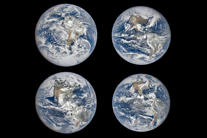
The four images show how EPIC’s view of the Western Hemisphere changes throughout the year:
- December solstice: South America is near the center of the disk, and much of the South Pole is visible. North America is partly hidden from view.
- March equinox: The hemispheres are transitioning between the seasonal extremes.
- June solstice: The Northern Hemisphere and North America are more centered. Arctic sea ice is visible, while South America is offset and Antarctica is completely hidden.
- September equinox: Earth is again positioned between the two solstices, with both hemispheres receiving nearly equal sunlight.
The most noticeable difference is between the two solstices. In December, the Southern Hemisphere is tilted toward the Sun. In June, Earth’s tilt reverses the view, bringing the Northern Hemisphere more directly into the center of the sunlit disk.
Why does Earth look slightly smaller in some images?
The four images also show subtle differences in Earth’s apparent size. During the March and September equinoxes, Earth appears slightly smaller because DSCOVR was tens of thousands of miles farther away than it was during the June solstice.
On December 21, 2023, DSCOVR was 1,447,327 kilometers (899,327 miles) from Earth. On September 22, 2024, it was 1,561,901 kilometers (970,520 miles) away.
These small changes in Earth’s apparent size are not caused by the planet’s tilt. Instead, they result from DSCOVR’s three-dimensional Lissajous orbit around the Sun-Earth Lagrange point 1.
At Lagrange point 1, the combined gravitational forces of the Sun and Earth balance the spacecraft’s centrifugal force. This makes it easier for engineers to maintain DSCOVR’s position while using relatively little fuel.
DSCOVR’s distance from Earth varies between maximum and minimum values approximately every three months. The timing changes throughout the year because of lunar influences and orbital maneuvers. In 2024, the spacecraft happened to be slightly farther from Earth during both equinoxes, although that is not always the case.
Why does Earth sometimes look more rounded?
Another difference between the images comes from the angle between the Sun, Earth and DSCOVR. Because of the spacecraft’s Lissajous orbit, this angle varies between about 2 and 12 degrees, according to Alexander Marshak, deputy project scientist for the DSCOVR mission.
At smaller angles, Earth appears as a fully illuminated disk. At larger angles, it appears more rounded, similar to the changing phases of the Moon. In this series of images, the September 22 image was taken at an angle of 8.1 degrees, while the December 21 image was taken at an angle of 10.3 degrees. As a result, the September image appears slightly rounder and fuller. The angles in the other two images were between 9 and 10 degrees.
“These images show subtle effects of changing orbital geometry,” Marshak said. “But the most obvious change, the apparent position of the continents, is due to the tilt of the Earth.”
What EPIC reveals about Earth
EPIC’s perspective makes it easier to understand and visualize why Earth has seasons. After 10 years in space, the mission has also opened new ways to study how daily and seasonal cycles unfold across the planet.
For more than a decade, EPIC has collected data on important features of Earth, including vegetation, clouds, ice, snow, ultraviolet light, ocean color and aerosols. Its observations provide a global view of how Earth changes over time.
NASA Earth Observatory imagery using data from Michala Garrison and DSCOVR EPIC. Story by Adam Voiland.
Image dates
December 21, 2023
March 19, 2024
June 20, 2024
September 22, 2024
Sources and further reading
- Kostinski, A. et al. (2024). Deep space observations of conditionally averaged global reflectance patterns. Frontiers in Remote Sensing, 5, 1404461.
- Kostinski, A. et al. (2021). Deep space observation of the Earth’s glow. Earth and Space Science, 8, e2020EA001521.
- Lyapustin, A. et al. (2026). Editorial: Earth observation from deep space: 10 years of the DSCOVR mission. Frontiers in Remote Sensing, 7, 1810164.
- NASA (June 19, 2026). Earth Polychromatic Imaging Camera. Accessed September 21, 2026.
- NASA Earth Observatory (September 23, 2011). Observing the vernal equinox and summer solstice from space. Accessed September 21, 2026.
- NASA (2026). EPIC publications. Accessed September 21, 2026.
- NASA Science Visualization Studio (December 27, 2012). Earth orientation animation.
- NASA Space Place (July 31, 2026). What causes the seasons? Accessed September 21, 2026.
- Roberts, C. et al. (2015). Initial mission maneuver operations for the Deep Space Climate Observatory Sun-Earth L1 Libration Point Mission.
- Valero, F. et al. (2021). Lagrange Point Mission: The key to the next generation of integrated Earth observation. DSCOVR Innovation.
Source: science.nasa.gov