


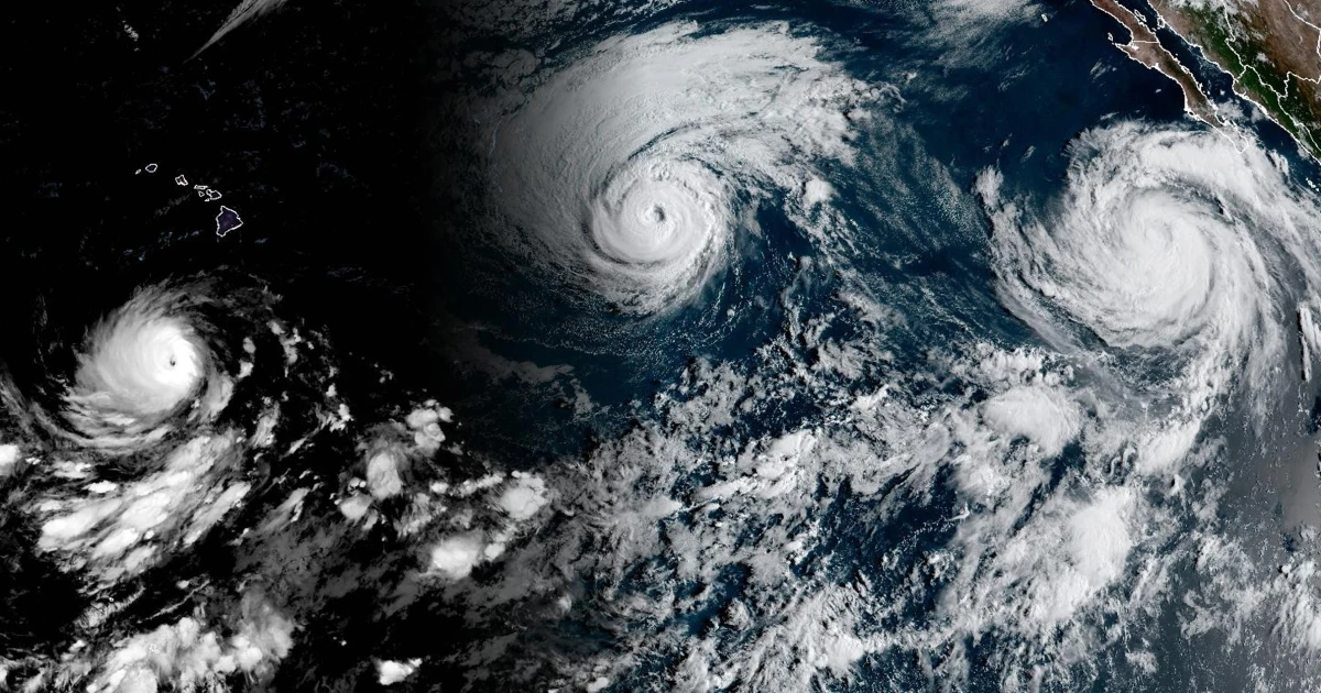
Three hurricanes — Carina, Lowell and Marie — are churning across the Pacific Ocean as climate scientists point to unusually active hurricane conditions linked to El Niño. Forecasters warn that this season could produce some of the strongest Pacific hurricanes on record.
Two of the storms reached major-hurricane strength this week. Lowell intensified to Category 5 status on Wednesday before weakening to Category 3. The hurricane is moving west and could approach Hawaii this weekend, although forecasters expect it to turn sharply northward. The National Hurricane Center is closely monitoring the storm’s potential effects near Oahu and Kauai. National Hurricane Center forecast.
The threat comes as Hawaii continues to recover from repeated episodes of heavy rain and flash flooding over the past six months. Just weeks ago, parts of Oahu and the Big Island experienced severe flooding and damaging winds from Tropical Storm Lala. Significant damage also remains from flooding in March, when parts of Oahu recorded more than 25 inches of rain and areas of Maui received over 19 inches.
Carina has weakened from Category 3 to Category 2 strength east of the Hawaiian Islands and is expected to lose additional strength during the next 48 hours, according to the Hurricane Center. Meanwhile, Hurricane Marie, located about 400 miles off Mexico’s Baja California Peninsula, is strengthening. The storm could generate dangerous swells along Mexico’s southwestern coast, Baja California and possibly Southern California this weekend. According to the National Hurricane Center.
The simultaneous presence of three Pacific hurricanes reflects an increase in tropical activity that is consistent with El Niño, a natural climate pattern associated with warmer-than-average sea surface temperatures across parts of the Pacific Ocean.
The National Oceanic and Atmospheric Administration, along with other forecasting agencies, is predicting an exceptionally strong El Niño this year. Sometimes referred to as a “Super El Niño,” the event is marked by Pacific Ocean temperatures at least 2 degrees Celsius, or 3.6 degrees Fahrenheit, above average.
NOAA’s forecast last month indicated a 69% chance that this El Niño could become the strongest on record.
El Niño can amplify the warming effects of human-caused climate change, raising global temperatures and increasing the risk of extreme weather events.
During El Niño years, warmer ocean waters can help more Pacific storms form and intensify. Daniel Guilford, a meteorologist and atmospheric scientist with the nonprofit research organization Climate Central, compares tropical cyclones to engines powered by warm ocean water.
“You need some type of fuel to convert the engine to wind power,” he said. “Increasing the amount of fuel available for a storm is like increasing the speed limit on your car. If you have more fuel, you can press the gas pedal harder, which can make the storm more intense.”
This El Niño event is unfolding while Pacific sea surface temperatures are already unusually high. Scientists have been monitoring a widespread ocean heat wave that began last year, bringing an extended period of abnormally warm water. Guilford said Climate Central’s early research found that about 94% of the Pacific Ocean had experienced heat-wave conditions since January, with some areas measuring as much as 2 degrees Celsius above normal.
“Temperatures are rising across the Pacific, and we’re certainly seeing that trend in areas where hurricanes and tropical cyclones pass through,” he said.
While the Pacific is experiencing a surge in hurricane activity, conditions in the Atlantic basin remain relatively quiet, Guilford said. That contrast is another typical feature of El Niño.
“El Niño changes the winds in the atmosphere in a way that is not conducive to storm formation in the Atlantic,” he said. “That’s exactly what we’re seeing now.”
Although El Niño is a natural climate pattern, scientists say climate change may be making these events more intense. A study published last month in the journal Science found that El Niño events have strengthened since humans began burning fossil fuels and releasing heat-trapping greenhouse gases.
United Nations Secretary-General António Guterres said Thursday that El Niño was “supermassifying before our eyes” and called the rapidly changing conditions a warning that urgent climate action is needed.
“The science is in no doubt: The Earth is in uncharted waters, and those waters are heating up,” Guterres said in response to a new report from the World Meteorological Organization. “Sea surface temperatures are rising, temperatures continue to rise, and the world is in the danger zone of extreme weather events. There is now a competition between increasing risks and our commitment to take climate action and protect people. We must win that competition.”
Source: www.nbcnews.com