


NASA Satellite Image Reveals a Cloudy Cloak Over Washington and Oregon
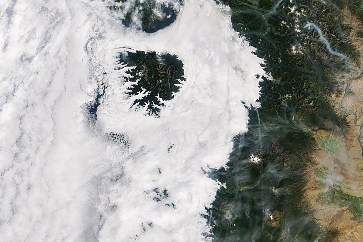
Marine clouds and fog stretched from the Pacific Coast to the Cascade foothills on September 19, 2026, while mountain peaks rose above the cloud layer like islands.
A blanket of marine clouds covers the Pacific Northwest
In mid-September 2026, cold sea breezes flowing inland from the Pacific Ocean created a picturesque layer of low clouds over western Washington and Oregon. The clouds and fog extended inland to the western foothills of the Cascade Mountains.
Near the coast, the higher parts of Washington’s Olympic Mountains and Oregon’s Coast Range rose above the clouds, appearing like islands surrounded by a sea of white.
A MODIS instrument aboard NASA’s Terra satellite captured the scene on September 19, 2026, at approximately 10:45 a.m. Pacific Time, or 17:45 UTC. Extensive clouds also covered the Pacific Ocean offshore, while smoke from wildland fires filled valleys in the North Cascades.
How the marine layer formed
For several consecutive nights, cool marine air moved over the land. This flow produced low-level clouds known as a marine layer.
Marine stratus clouds form when moist air near Earth’s surface becomes trapped beneath a layer of warmer air. This temperature inversion prevents the air from rising freely. As the moist air cools, water vapor condenses into clouds and fog.
During the early morning hours of September 19, the surge of cool, damp air became especially strong. The resulting cloud cover reached inland to the Cascade foothills, and in some locations the fog descended all the way to the ground.
Afternoon skies clear inland
NASA’s Aqua satellite passed over the region at approximately 4:15 p.m. Pacific Time, or 23:15 UTC, the same day. By then, skies had cleared across most of the region.
Some clouds remained over the ocean and clung to the Oregon coast, where temperatures were much cooler than in inland areas, according to the National Weather Service.
These recurring summer and early-autumn low clouds are a familiar feature of the Pacific Northwest. Their extent and persistence are influenced by cool ocean waters, onshore winds and atmospheric temperature inversions.
NASA Earth Observatory image by Michala Garrison using NASA MODIS data from LANCE and GIBS/Worldview. Story by Lindsay Dorman.
Sources
- Dye, A. W., et al. (2020). Pacific Northwest summer low cloudiness spatial patterns and trends, 1996–2017. Geophysical Research Letters, 47, e2020GL088121.
- EUMeTrain: Fog and stratus clouds.
- National Weather Service: What are marine stratus clouds and how do they form?
- National Weather Service Portland, Oregon: Area Forecast Discussion.
- National Weather Service Seattle: Area Forecast Discussion.
Source: science.nasa.gov