


NASA Data and AI Forecasts Help Washington Manage 2026 Snow Drought
The effects of the 2026 western U.S. snow drought are continuing into summer, and NASA Earth observation data is helping power machine learning forecasts that guide water management, hydropower generation, and public safety decisions in Washington state.
Tacoma Power uses river flow forecasts from U.S.-based technology company Upstream Tech to prepare for changing conditions on the Cowlitz River. The utility’s largest hydroelectric project relies on water stored behind Mayfield and Mossyrock dams to generate enough electricity to power more than 151,000 homes each year.
Upstream Tech’s HydroForecast combines weather predictions, river measurements, and NASA satellite observations of snowpack and vegetation conditions to forecast river flows hours to days in advance. Updated every two hours, the forecasts help reservoir managers, hydropower producers, water utilities, and government agencies prepare for storms, plan reservoir releases, and manage water supplies during dry periods.
“Part of NASA’s mission is to make the view from space useful here on Earth,” said Erin Urquhart, water resources program manager at NASA Headquarters in Washington, D.C. “When American companies incorporate NASA’s freely available data into forecasts that help water managers prepare for floods, generate electricity, and manage water supplies, they are providing practical value to the nation.”
During the winter of 2025–2026, unusually warm temperatures caused more precipitation to fall as rain instead of snow across much of the West. Some regions also experienced below-normal precipitation and severe snow deficits. According to NASA MODIS (Moderate Resolution Imaging Spectroradiometer) satellite records dating back to 2001, January, February, and March each had the lowest snow coverage in the West for those months.
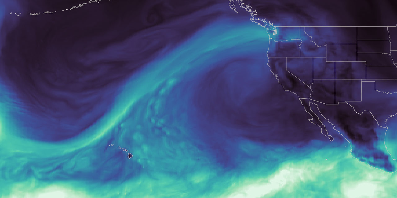
The Cowlitz River basin experienced extreme and rapidly changing conditions. In December 2025, a powerful atmospheric river carried a narrow band of moisture from the Pacific Ocean into the region, producing one of the largest daily inflow surges ever recorded at Tacoma Power’s hydroelectric project. During the rest of the season, low mountain snowpack caused water to move downstream quickly rather than melt gradually and sustain river flows into summer. Snowfall remained at just 20% to 50% of normal levels.
Rainfall gradually declined as winter shifted into spring. On April 8, Washington state declared a statewide drought emergency covering all watersheds, including the Cowlitz River. From April through June, peak daily inflows to the hydroelectric project ranked among the lowest on record. The reduced inflow limited Tacoma Power’s ability to replenish reservoirs before the summer demand period, said Saul Villarreal, Tacoma Power’s senior hydro operations manager.
NASA’s satellite observations include data from the VIIRS (Visible Infrared Imaging Radiometer Suite) instrument aboard the Suomi National Polar-orbiting Partnership satellite. These observations provide information on snow cover and vegetation health throughout the river basin, including remote areas where ground-based monitoring stations are limited.
To train HydroForecast, Upstream Tech collects and archives years of NASA satellite products, weather forecasts, and measured river flows. The machine learning model analyzes data from hundreds of watersheds to identify common patterns in how water moves across different landscapes. It then applies those patterns to forecast conditions in new locations.
Tests across multiple watersheds have shown that adding satellite observations of snow and vegetation improves forecast performance, said Dr. Laura Reed, Upstream Tech’s director of hydroforecast technology and federal partnerships.
“NASA’s data gives us the reliability, global reach, and consistency we need,” Reed said. “Our short-term models run every two hours, so these inputs need to be available when they are needed. Any disruption to our operational data pipeline would be a major problem.”
Tacoma Power uses HydroForecast alongside flow meters, snow monitoring stations, and operator expertise. During the December atmospheric river, short-term forecasts incorporating NASA data helped the utility estimate how much water would reach its projects. The information supported rapid operational decisions while helping Tacoma Power meet safety and reliability requirements.
As spring approached, the operational challenge shifted from managing excessive inflows to preparing for weak runoff. Tacoma Power used HydroForecast’s seasonal model to track the growing risk of below-normal water supplies and began keeping reservoirs higher than usual to preserve water for summer.
With less reservoir capacity available to absorb another major storm, operators continued monitoring short-term forecasts closely and remained prepared to adjust operations if additional atmospheric rivers developed.
“The sooner we understand how conditions will change, the more effectively we can plan reservoir operations and balance the system’s many demands throughout the season,” Villarreal said.
Tacoma Power entered summer 2026 with near-average reservoir levels despite the dry spring. Stored water helps maintain river flows for reliable hydropower generation, fish and aquatic habitat, and public recreation. It also gives the utility greater flexibility to respond to heat waves, unexpected power outages, and regional electricity needs when possible.
The Cowlitz Hydroelectric Project is one example of how NASA Earth science supports water management decisions across the western United States.
NASA is also working with the U.S. Department of Agriculture’s Natural Resources Conservation Service to incorporate satellite-based snowpack and groundwater information into machine learning models that forecast water supplies.
The National Oceanic and Atmospheric Administration’s Colorado Basin River Forecast Center uses MODIS and VIIRS data to improve snowmelt estimates in its forecasting models. The Bureau of Reclamation also uses NASA and NASA-derived snow data, along with other information sources, to support reservoir operations in California’s San Joaquin Basin.
NASA data and research have long supported the U.S. Drought Monitor, a weekly assessment used by farmers, water managers, and public agencies. In 2026, NASA became a formal partner, expanding its role from supplying data to helping develop drought assessments. The agency produced its first drought monitor during the week of August 17.
Source: science.nasa.gov