


Indonesia’s 2026 Peat Fires Blanket the Region in Smoke
In tropical peatlands, fire can behave like an apex predator—moving slowly, producing intense pollution and resisting conventional firefighting efforts. Unlike ordinary forest fires, peat fires can smolder underground through thick layers of carbon-rich soil. They burn at relatively low temperatures, may remain hidden beneath smoke and vegetation, and can continue spreading until heavy rainfall arrives.
Research indicates that tropical peat fires can occur more frequently than fires in other tropical forests and release substantially higher levels of pollution. Compared with other tropical forest fires, peat fires can produce approximately five times more sulfur dioxide, three times more organic carbon, and twice as much methane and carbon monoxide. They also release significant amounts of particulate matter, which can pose serious risks to public health.
NASA Satellite Image Shows Indonesia’s Fire Season
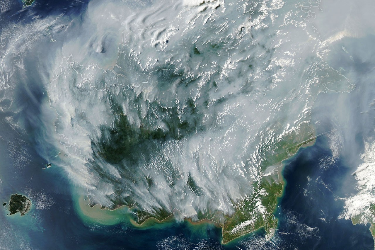
Indonesia’s 2026 fire season was underway by September. On September 1, NASA’s Moderate Resolution Imaging Spectroradiometer (MODIS) aboard the Aqua satellite captured the smoke and fire activity across the region.
In the accompanying map, each red dot represents a satellite-detected thermal anomaly that may indicate an active fire. NASA identifies these fire detections using sensors and computer algorithms. Because one fire can cover a large area, a single event may generate multiple detections.
Why Peat Fires Are So Difficult to Extinguish
Peat fires are a recurring environmental and public health problem in Indonesia, which contains an estimated 36 percent of the world’s tropical peatlands. During severe droughts, peatlands in Sumatra, Kalimantan and Papua can dry out enough for fire to move below the surface.
Surface fires may be visible and accessible to firefighters, but underground peat fires are much harder to locate and suppress. They can smolder for weeks or months, producing persistent haze and reigniting when conditions become dry again.
“Surface fires are less of a concern, but once they get underground, they can’t be stopped,” researcher Robert Field said. “They will continue to burn until the rains arrive, typically in October or November.”
Drought and El Niño Increase Indonesia’s Fire Risk
Indonesia experiences fires every year, but the largest outbreaks have often occurred during strong El Niño events, including in 1997 and 2015. El Niño can reduce rainfall across Indonesia and extend the dry season. The climate patterns monitored by NOAA indicated unusually dry conditions in 2026, while the Indian Ocean Dipole also influenced regional weather patterns.
According to Indonesia’s meteorological agency, approximately 90 percent of the country experienced little to no rainfall in early August 2026. Under normal conditions, wet peatlands help prevent fires from spreading underground. Extended drought, however, lowers water levels and leaves peat deposits highly vulnerable to ignition.
In 2015, Indonesian fires burned for more than three months and released an estimated 1.75 billion tons of greenhouse gases—more than Japan emits in a year. By September 2, 2026, the current fire season had lasted roughly a month and had released an estimated 10 percent of the emissions associated with the 2015 fires.
Satellite Monitoring Helps Track Active Fires
The Indonesian government uses NASA and NOAA observations from VIIRS and MODIS sensors to monitor active fires in near real time. Indonesia’s Ministry of Forestry also operates a fire-monitoring platform based on MODIS and VIIRS data. On August 31, 2026, the platform recorded 946 hotspots.
However, satellite fire detection has important limitations. Thick smoke, clouds, forest vegetation and underground peat can hide fires from orbiting sensors. During the most severe smoke events, the number of recorded fire detections may actually decline.
“Paradoxically, the worst smoke events are the most difficult to observe from space using MODIS and VIIRS,” said Mark Cochran, an ecologist at the University of Maryland Center for Environmental Science who has studied Indonesian peat fires for nearly a decade.
Drainage and Land Use Have Increased Fire Risk
Large-scale irrigation canals and peatland drainage projects built during the 1990s, including efforts associated with the Mega Rice Project, significantly lowered water tables in some wetland areas. Drier peat is more flammable and allows fires to spread farther underground.
Oil palm plantations and other forms of plantation forestry are also widespread in parts of the region. Following the destructive 2015 fire season, Indonesian authorities and other organizations began blocking drainage canals, restoring wetlands, strengthening firefighting capabilities and working to reduce accidental and human-caused ignitions.
“This year will be a real stress test of the measures put in place since 2015,” said Shi Jun Wee, a graduate student at the University of Maryland.
New Satellite Tools Could Improve Fire Detection
Researchers are developing new methods to identify fires that remain hidden beneath forest canopies or smoke. The MapBiomas team uses shortwave-infrared observations from Landsat and Sentinel-2 satellites to develop algorithms capable of detecting more understory fires than traditional MODIS and VIIRS monitoring.
Researchers can also use NASA’s Worldview data browser, the Fire Information for Resource Management System (FIRMS), Harmonized Landsat and Sentinel-2 (HLS) observations, and the Global Fire Emissions Database (GFED) to monitor fire activity, smoke and emissions.
Smoke Disrupts Daily Life Across Southeast Asia
Smoke from Indonesia’s peat and forest fires is already affecting communities across the country and in neighboring nations. Indonesian authorities have warned that large portions of the population are being exposed to unhealthy air pollution.
Some schools have shifted to remote learning, while nine national parks have been temporarily closed. Smoke has also contributed to flight delays and reduced visibility in affected areas.
“During El Niño events, people tend to focus on these fires and then forget about them,” Cochran said. “Solving this requires continued attention, even during less severe years. These fires produce a tremendous amount of exhaust gas.”
NASA Earth Observatory image by Lauren Dauphin, using NASA MODIS data from LANCE and GIBS/Worldview. Article by Adam Voiland.
Sources
- BMKG. Analysis of Atmospheric Dynamics, August 2026. Accessed September 2, 2026.
- Channel News Asia. Indonesia temporarily closes nine national parks due to forest fires. September 2, 2026.
- The Conversation. Borneo’s wildfires are surging again: Why El Niño isn’t the only culprit. August 23, 2026.
- Field, R. et al. Fire activity and smoke pollution in Indonesia in 2015. PNAS, 2016.
- Ministry of Forestry, Republic of Indonesia. Latest update on forest and land fires. August 31, 2026.
- NASA Earth Observatory. Observations from Indonesia’s severe fire seasons.
- ReliefWeb. Indonesia: Forest fires and haze in Sumatra and Kalimantan. August 25, 2026.
- van der Werf, G. et al. Landscape fire emissions from the fifth version of the Global Fire Emissions Database. Scientific Data, 2025.
- Yokelson, R. et al. Tropical peat fire emissions: Synthesis of field measurements in Sumatra and Borneo. Atmospheric Chemistry and Physics, 2022.
Source: science.nasa.gov