


A 3D Map Reveals How Deep Sediment Beneath Los Angeles Could Amplify Earthquake Shaking
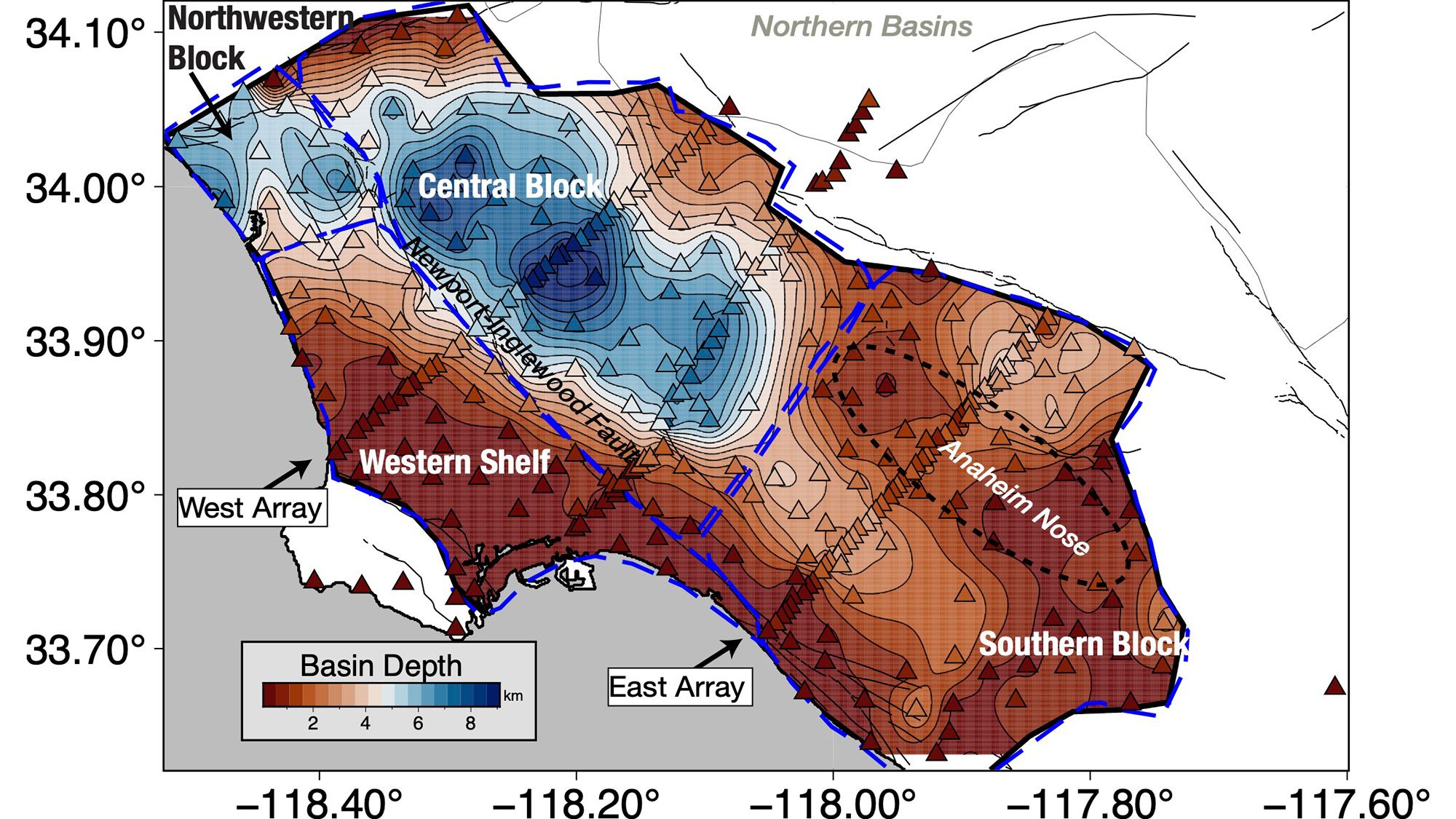
Scientists have created the most detailed three-dimensional map yet of the ground beneath Los Angeles—and it shows that downtown Los Angeles sits above as much as 6.2 miles (10 kilometers) of sediment.
That deep sediment could amplify seismic waves during an earthquake, potentially increasing shaking in parts of the Los Angeles Basin. The new underground map does not identify exactly where the strongest damage would occur, but it gives earthquake scientists a more accurate way to model which areas may be most vulnerable.
Why the Los Angeles Basin could intensify shaking
Los Angeles is built on a sedimentary basin, a low-lying region where layers of material have accumulated for at least 15 million years. The basin was initially underwater, allowing marine sediment to form its deepest layers. Later, tectonic movements turned the area into dry land, while nearby mountains supplied additional sediment.
The deepest sediments lie beneath the central part of the basin, including downtown Los Angeles. Along the basin’s edges, sediment is thinner, ranging from about 0.6 to 2.5 miles (1 to 4 kilometers) before reaching the hard crystalline rock beneath it.
Soft, deep sediment can change the way seismic waves move through the ground. Irregularities along the basin’s edges may also concentrate or redirect those waves.
“With this improved basin model, we can now understand the shape of the basin edge in greater detail,” Elizabeth Cochran, a U.S. Geological Survey seismologist who was not involved in the study, told Live Science.
Cochran noted that the 1994 magnitude 6.7 Northridge earthquake caused more shaking damage than expected in Santa Monica as seismic waves traveled along the basin rim.
The first complete 3D map of the Los Angeles Basin
Researchers already knew the basin’s general shape, but previous surveys provided only limited underground views. Those studies typically used linear arrays that crossed a single section of the basin.
“Previous surveys were just linear arrays through just one cross section of the Los Angeles Basin, but this is the first complete three-dimensional map,” Valeria Villa, a doctoral student at the California Institute of Technology and co-author of the study, told Live Science.
The study describing the map was published Aug. 4 in JGR: Solid Earth.
3D printed model of the Los Angeles sedimentary basin.
Image credit: Valeria Villa/California Institute of Technology
How scientists mapped the underground structure
The new map was built using data from 273 temporary seismic stations installed around Los Angeles. The stations detected weak seismic waves generated by distant earthquakes—waves too subtle for people to feel.
By analyzing the paths and timing of those waves, researchers reconstructed the three-dimensional structure of the rock formations beneath the Earth’s surface. The result provides a more detailed picture of the basin’s depth, shape and edges.
What the map means for future Los Angeles earthquakes
The map alone cannot determine exactly where shaking would be most severe during a major earthquake. The level of damage would depend on several factors, including which fault ruptures and how the earthquake’s seismic waves interact with the basin.
Los Angeles is surrounded by multiple faults, including the San Andreas Fault. A magnitude 7.8 earthquake scenario would cause intense shaking across Southern California, according to an earthquake simulation from the U.S. Geological Survey.
However, the improved basin model will allow geophysicists to update their simulations and test different earthquake scenarios, Villa said.
Why building resonance matters
One important factor in earthquake damage is resonance—whether a building sways at a similar rate to the sediment beneath it.
If a building and the ground resonate together, the resulting motion can become stronger and cause more damage. A better understanding of the sediment layers beneath downtown Los Angeles could help engineers design structures to reduce this effect.
“For example, you can change the stiffness of the building or do other things to offset this effect,” Cochran said. “The important thing is to know what the ground is like under the area you’re building and what the larger geological structure is like so you know that this could be an issue.”
Villa, V., Clayton, R. W. (2026). “Three-dimensional structure of the Los Angeles Basin and its underlying Moho.” JGR: Solid Earth, 131(8).
Source: www.livescience.com