


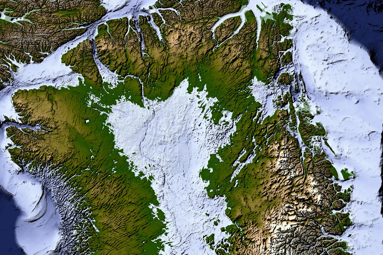
New Map Reveals 1,943 Hidden Valleys Beneath Greenland’s Ice Sheet
Greenland is covered by a vast ice sheet spanning about 1.7 million square kilometers (656,000 square miles). At its thickest point, the ice is more than 3 kilometers (1.9 miles) deep. Beneath it lies a landscape humans have never seen directly—but a new mapping method has produced the most detailed and accurate view yet of Greenland’s hidden bedrock.
A new map reveals an extensive network of valleys carved into the terrain beneath the Greenland Ice Sheet. Much of this landscape formed long before most of the ice covering it existed, offering new insight into Greenland’s geological history and potentially helping scientists improve predictions of the ice sheet’s future.
The research was led by NASA scientists and published in Geophysical Research Letters in a paper by Chartrand and colleagues.
How scientists mapped Greenland’s hidden bedrock
The new map was created using a technique called ice-flow perturbation analysis. As ice moves over buried valleys and ridges, the underlying topography leaves faint traces on the ice surface. Satellites can detect these subtle irregularities, allowing scientists to infer the shape of the landscape beneath the ice.
The technique is intended to improve future versions of BedMachine Greenland, a high-resolution dataset of the topography beneath the ice sheet.
Using the method, researchers manually mapped 1,943 subglacial valleys beneath Greenland’s ice. About one-third of them had not previously been identified. The researchers found that approximately half of Greenland’s valleys are located primarily near the edge of the ice sheet, although many extend much farther inland than existing maps show—sometimes for hundreds of kilometers.
Ancient valleys and mountain ranges beneath the ice
Several features on the new map match scientists’ current understanding of how Greenland’s landscape formed. Many valleys appear to begin in the island’s southern and eastern highlands, where ice sheets are thought to have first developed.
Near the eastern highlands, the map shows mountain ranges beneath the ice, interconnected valleys and increasingly rugged terrain toward the coast. These alpine-like landforms may have remained preserved beneath the ice since at least the Pliocene.
Why are some Greenland valleys so straight?
Other features of the buried terrain are more difficult to explain. In the west-central region, many valleys are long, straight and aligned in a southwest-to-northeast direction.
This alignment may indicate a tectonic influence, creating preferred pathways for water flow and valley formation. However, the pattern remains puzzling.
“It’s a mystery to us,” said Joe MacGregor, a cryosphere scientist at NASA and co-author of the study. “Greenland is normally treated as a solid block of old rock that is simply transformed as needed to accommodate the movements and interactions of other plates, which makes sense.”
The angle at which the valleys diverge also offers clues about how they formed. Their relatively wide divergence angles suggest that surface water alone did not carve them. Instead, an extensive groundwater network may have helped erode the surrounding rock before the Greenland Ice Sheet formed.
How valleys guide ice flow and glacier formation
Mapping Greenland’s hidden valleys is important because ice flow is concentrated in these low-lying channels. Valleys help guide glaciers toward the coast, where the ice eventually breaks apart into fjords.
This process can create a reinforcing cycle: ice flowing through a valley becomes thicker, thicker ice moves faster, and faster-moving ice can deepen the valley further.
The effect is especially visible along western Greenland. MacGregor compared the region’s deeply carved landscape to Yosemite, describing the west coast as “El Capitan after El Capitan.”
What the new map reveals about Greenland’s future
The valley network may also help scientists understand how the ice sheet will respond as it retreats. Because ice flow tends to remain concentrated in existing troughs, future ice loss may continue to channel faster-moving ice through the same buried valleys.
“The better we understand the landscape now, the better we can understand what the landscape will look like in the long term, beyond the next 10 or 20 years, as faster ice flows propagate into interior Greenland,” MacGregor said.
By revealing the hidden bedrock beneath Greenland, the new map gives researchers a clearer view of the ancient landscape shaping the ice sheet today—and a better basis for modeling how Greenland’s ice may change in the future.
NASA Earth Observatory map using data from Lauren Dauphin. Research by Chartrand et al.; story by Kathryn Hansen.
Source: science.nasa.gov