


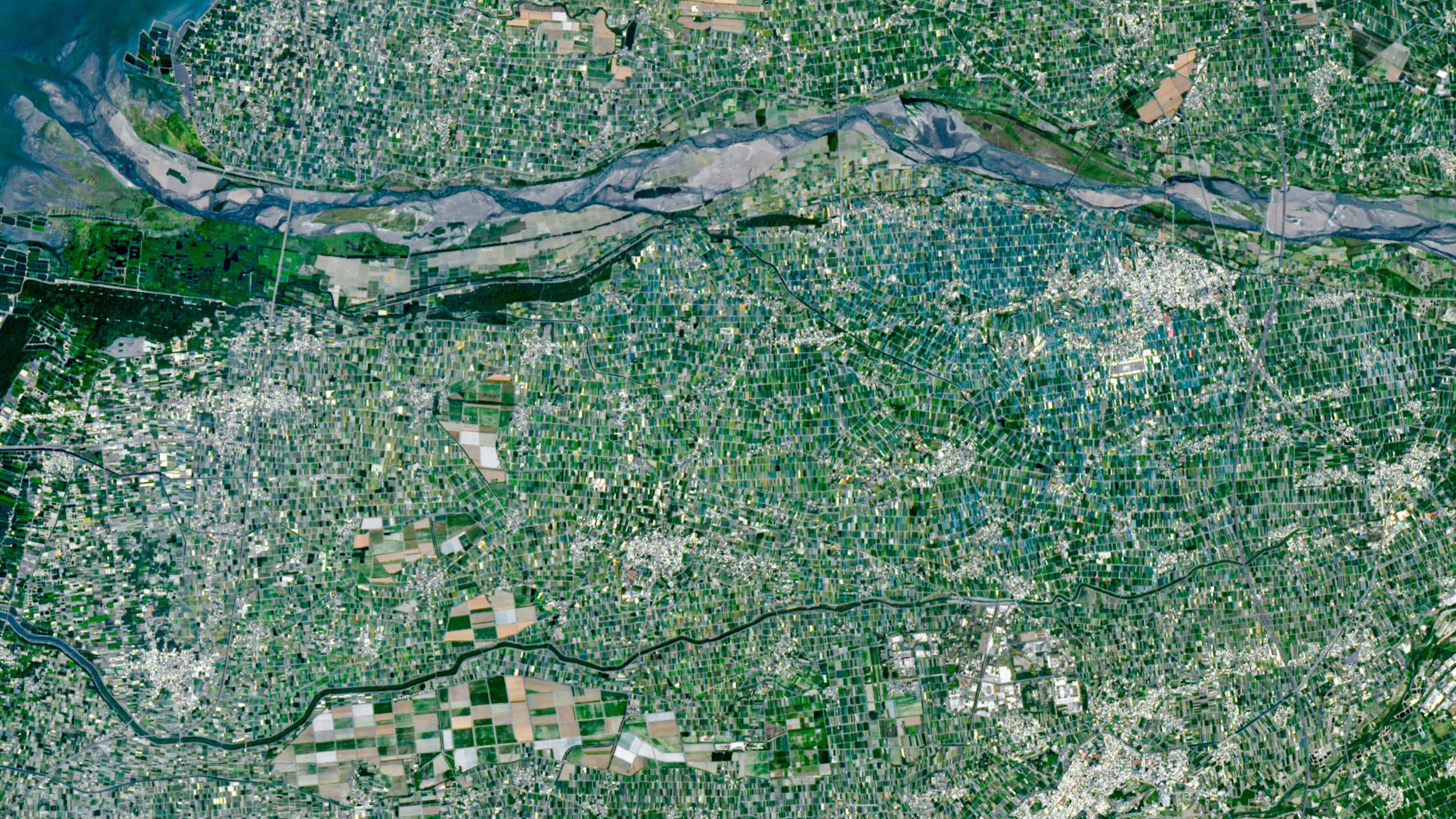
A Satellite View of Taiwan Reveals a Colorful Mosaic of Tiny Farms
Simple facts
Where is it? Taiwan’s Jianan Plain, Yunlin County [23.78563273, 120.44373747]
What is in the photo? A colorful mosaic of small, tightly packed farms
Which satellite took the photo? Landsat 9
When was the photo taken? April 24, 2026
A recent Landsat 9 satellite image reveals a colorful mosaic of dense mini-farms across Taiwan’s western Pacific coast. The patchwork of fields, shade nets and livestock farms illustrates the agricultural challenges facing the densely populated island.
At 14,000 square miles (36,000 square kilometers), Taiwan is about the same size as Maryland but has roughly four times the population, with about 23 million people, according to NASA Earth Observatory. This puts considerable pressure on Taiwan’s agriculture, particularly because much of the island is covered by mountains and rainforest.
Researchers estimate that Taiwan has only about 3,200 square feet (300 square meters) of farmland per person — roughly two-thirds the size of a basketball court. That is about one-tenth of the equivalent amount available to U.S. residents.
Why Yunlin County is Taiwan’s agricultural heartland
Much of Taiwan’s food is produced in Yunlin County, located approximately midway along the Jianan Plain, a long stretch of flat terrain on Taiwan’s west coast. The satellite image shows just under half of the county, which spans approximately 15 miles (24 kilometers).
Yunlin’s flat terrain and access to water from the island’s largest river, the Zhuoshui, make the county well suited to growing a wide range of crops. These include rice, sweet potatoes, peanuts, corn, sugar cane, garlic, leeks, coffee, fruits and leafy vegetables, Earth Observatory representatives wrote.
The limited size of farms in Taiwan allows very different crops to be grown in parallel.
Image credit: Marek Ślusarczyk (Tupungato) via Wikimedia
The average farm in Yunlin County is less than 100,000 square feet (10,000 square meters), making it about 90 times smaller than the average farm in the United States. Viewed from above, the region resembles a giant patchwork of tens of thousands of irregular fields.
According to Earth Observatory, long-standing laws that limit the amount of land individuals can own have helped keep farms small. Most farms are passed down from generation to generation.
Two unusual patterns stand out from space
The agricultural mosaic is fairly consistent across the image, but two areas stand out.
The first is a cluster of blue and turquoise rectangles surrounding the town of Xiluo in the upper right of the image, just below the river. These farms are covered with plastic blackout netting to protect crops from the strong summer sun and monsoon rains during the rainy season.

From space, two particular areas of Yunlin County stand out.
Image credit: NASA/Landsat 9
The second, and perhaps most striking, anomaly is a much larger, brightly colored cluster of farms near the city of Baozhong in the lower left of the image. These are sugar cane fields that remain from the period when Japan ruled Taiwan from 1895 to 1945.
Much of the Jianan Plain was once used by the Japanese to grow sugar cane. Railroads were also built to transport the crop around the island. Most of those fields have since been repurposed, and all but one of the railway lines have fallen into disuse.
Small farms support crops and livestock
In addition to growing crops, Yunlin County’s small farms are used to raise livestock, including chickens, cows and “millions of pigs,” according to Earth Observatory.
Topics
Source: www.livescience.com