


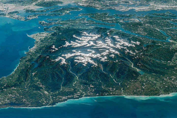
Discover the stunning Olympic Peninsula, located in the northwestern corner of Washington state. This diverse landscape features majestic alpine glaciers, rugged coastline, lush temperate rainforests, and deep river valleys. Enclosed by tranquil blue waters, serene islands, and vibrant cities, the peninsula’s rugged interior serves as a remote wilderness haven.
Oblique photographs captured by astronauts aboard the International Space Station showcase the remarkable topography of the Olympic Mountains. These composite images merge several overlapping photos to create breathtaking panoramas. Olympic National Park encompasses the mountainous heart of the peninsula as well as parts of the Pacific coastline, with much of the surrounding area designated as either national forest, state land, or tribal territory, as highlighted in this map.
The mountains’ geology dates back to when most of their rocks were formed below sea level, from around 55 million to 15 million years ago. Layers of basalt from submarine eruptions, along with sand and sediment brought to the sea by rivers, accumulated on the ocean floor. The subduction of the Juan de Fuca plate beneath the North American plate resulted in the elevation of these formations, raising peaks to heights of up to 8,000 feet (2,440 meters) above sea level, as evidenced by the geological activity.
Despite ongoing tectonic movements pushing the mountains upward, erosion from rain and snow continuously counteracts these forces. Snow accumulation at higher elevations feeds glaciers, which meticulously carve the underlying rock. The Olympic glaciers are, however, retreating and thinning, with a notable study showing that 255 glaciers and permanent snow fields were documented in the mountain range during 2015. Alarmingly, it was found that 35 glaciers and 16 permanent snowfields have vanished over the past 35 years.
Evidence of erosion can be seen in the deep valleys radiating from the snow-capped peaks. This striking view includes the Hoh, Queets, and Quinault rivers, which flow into the Pacific Ocean. These vibrant valleys, part of the renowned temperate rainforest ecosystem, include the Ho River Valley, historically viewed as a vital forest ecosystem. It stands as one of the most naturally serene places in the U.S., free from man-made noise.
The Elwha River, flowing northward, offers rich natural and human history, marking the early European American expeditions into the Olympic Peninsula. An expedition sponsored by a Seattle newspaper from December 1889 to May 1890 navigated the mountains, traveling through the Elwha Valley. Despite their lengthy stay in the valley, they faced challenges from an unusually harsh winter.
In the early 1900s, valley entrepreneurs recognized economic potential, leading to the construction of two dams. These structures generated electricity for local industries but hindered trout and salmon migration to their spawning grounds. In a bid to restore natural fish populations and native plant communities, the dams—once the largest in the U.S.—were removed in 2011 and 2014, marking a new chapter in ecosystem restoration efforts.
The Elwha River’s mouth forms a delta within the Strait of Juan de Fuca, a vital waterway bordered by the northern part of the peninsula. The U.S.-Canada border bisects this 11- to 17-mile-wide (18- to 27-kilometer-wide) strait, with British Columbia’s Vancouver Island to the north. The strait connects the Pacific Ocean to the Strait of Georgia and Puget Sound, serving as a key shipping route for major West Coast ports like Seattle and Tacoma, clearly visible in the upper right portion of the image.
This stunning astronaut photo ISS047-E-104138 through ISS047-E-104144 was taken on May 6, 2016, with a Nikon D4 camera using a 400 mm focal length. Provided by the ISS Crew Earth Observation Facility and the Earth Science and Remote Sensing Unit at NASA Johnson Space Center, these images were captured by a member of the 47th Expedition Crew. The photographs have been cropped and enhanced for clarity, with lens artifacts removed, to enrich our understanding of Earth.
- Fountain, A.G.; Others. (2022). Glaciers in the Olympic Mountains, Washington – 100 Years Past and Future. Geophysical Research Journal: Earth’s Surface 127(4), e2022JF006670.
- NASA Earth Observatory (February 14, 2016). Olympic National Park. Accessed July 22, 2026.
- NASA Earth Observatory (August 25, 2012). Elwha River Restoration. Accessed July 22, 2026.
- National Park Service (July 7, 2026). Olympic National Park. Accessed July 22, 2026.
- Washington State Department of Natural Resources; Olympic Mountains. Accessed July 22, 2026.
Source: science.nasa.gov