


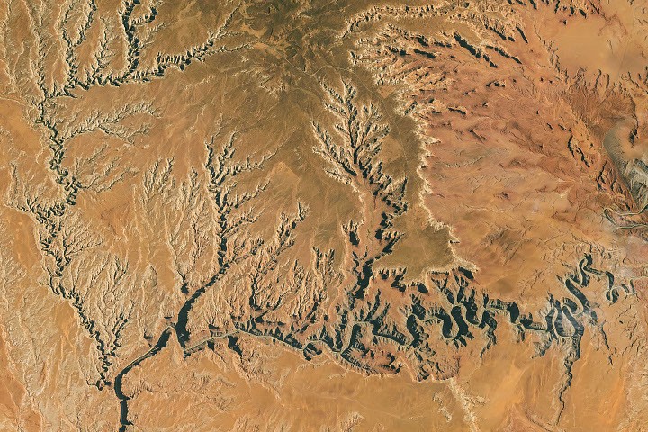
Tens of millions of years ago, the San Juan River in what is now southern Utah flowed across a relatively flat plain formed by an ancient marine environment, much like the modern Mississippi River. As geological forces uplifted the Colorado Plateau, the river’s gradient and erosive power increased. It cut progressively deeper channels through roughly 300-million-year-old rock, creating the dramatic, tightly looping canyon system known today as the Goosenecks.
How the San Juan River formed its goosenecks
On a broad, flat landscape, the San Juan could follow a long, winding route downhill. The river’s gradual meanders resembled those of large lowland rivers such as the Mississippi.
The later geological history of the Colorado Plateau remains partly mysterious. Some experts place an important stage of that history around 20 million years ago, when geological uplift altered the San Juan’s course and increased its gradient. As the river gained more erosive power, it carved deeper and tighter bends into the ancient bedrock.
Today, the San Juan flows westward toward Lake Powell through a series of entrenched meanders known as goosenecks. At Goosenecks State Park in Utah, the river occupies a canyon about 1,000 feet (300 meters) deep. In places, the channel appears to turn almost backward, forming horseshoe-shaped curves.
The river’s winding route can be dramatically longer than the straight-line distance across the desert. In some sections, it travels 5.5 miles (8.9 kilometers) between points only 1.3 miles (2.1 kilometers) apart.
A desert landscape photographed from orbit
On October 6, 2026, an astronaut aboard the International Space Station photographed the rugged desert landscape. The image, designated ISS075-E-188830, was captured with a Nikon Z9 digital camera using a 400-millimeter focal length. The photograph was taken by a member of the Expedition 75 crew.
NASA’s ISS Crew Earth Observation Facility and the Earth Science and Remote Sensing Unit at NASA’s Johnson Space Center provide astronaut photographs through the International Space Station program and the ISS National Laboratory. The images are made available to scientists and the public. This image was cropped and enhanced to improve contrast, and lens artifacts were removed.
Dark skies over Goosenecks State Park
The Goosenecks are striking during the day, but the remote high-desert setting also makes the area notable at night. Goosenecks State Park has 360-degree views of the sky and is recognized as an International Dark Sky Park.
According to DarkSky International, visitors can see features including the Double Cluster in Perseus and the Messier 24 nebula in the Milky Way’s Sagittarius spiral arm with the naked eye under suitable conditions. In November 2026, the Northern Taurid, Southern Taurid and Leonid meteor showers are expected to reach their peaks at different points during the month.
Photo credit: NASA astronaut photograph ISS075-E-188830; additional photo credit for the Goosenecks image: Bob Wick, Bureau of Land Management, via Flickr. Story by Lindsay Dorman.
Sources
- Dark Sky International, “Goosenecks State Park,” March 25, 2021. Accessed November 5, 2026.
- Karlström, K. E., et al., “Crustal structure of the Colorado Plateau and its margins,” Earth and Planetary Science Annual Review 50:295–322, 2022.
- NASA Earth Observatory, “The meandering Mississippi River,” July 19, 2020. Accessed November 5, 2026.
- Utah Geological Survey, “Geosite: San Juan River Gooseneck, San Juan County, Utah,” September 2013. Accessed November 5, 2026.
- Utah State Parks: Goosenecks State Park. Accessed November 5, 2026.
Source: science.nasa.gov