


El Niño Fuels a Severe Amazon Fire Season as Smoke Blankets Manaus
Satellite data show a sharp rise in fires and smoke across the central and eastern Amazon, with scientists warning that the danger could spread through 2027.
Unlike tornadoes and thunderstorms, which can cause destruction within minutes, El Niño affects weather patterns over several months. In 2026, El Niño-related drought has placed the Amazon rainforest at heightened risk of fire. Scientists say the region is in the early stages of what could become a long and severe fire season.
Satellite data reveal a sharp increase in Amazon fires
Since September 2026, satellites have detected a significant increase in fire activity and smoke emissions across the central and eastern Amazon. The trend is visible through monitoring platforms including NASA’s Fire Information for Resource Management System (FIRMS), the Global Fire Emissions Database (GFED), and NASA Worldview.
The area with active fires stretches from forests surrounding the commercial and transportation hubs of Manaus and Santarém to the mouth of the Amazon River.
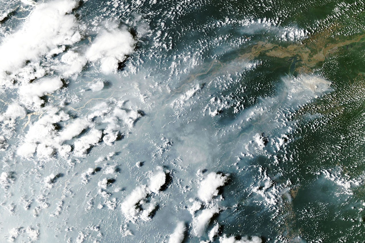
On October 12, 2026, NASA’s Aqua satellite captured smoke flowing from fires on both banks of the Amazon River. The satellite’s Moderate Resolution Imaging Spectroradiometer (MODIS) imagery showed Manaus, the capital of Brazil’s Amazonas state, covered by thick smoke.
Smoke disrupts daily life in Manaus
City officials reported that air quality in Manaus had become very poor, with afternoon PM2.5 particulate matter concentrations above 135 micrograms per cubic meter. The reading ranked as the second-worst level in the region’s air-quality index.
The smoke disrupted daily life for more than 2 million people. Schools were closed, and citywide events and children’s sports leagues were canceled as authorities warned residents about unsafe air quality. Associated Press coverage described the worsening conditions.
Scientists describe a cascade of tropical fires
Douglas Morton, an Earth system scientist at NASA’s Goddard Space Flight Center, said the fires around Santarém and Manaus are part of a wider “cascade” of tropical fires caused by El Niño’s disruption of rainfall patterns.
According to Morton, the pattern begins near the equator with drought and peat fires in Indonesia. Increased fire activity can then spread to the Amazon. Morton and colleagues at the University of California, Irvine; Vrije Universiteit Amsterdam; and the University of Maryland documented this pattern in their 2017 study of the pantropical fire cascade, following the destructive 2015–2016 El Niño fire season.
The same pattern was also observed in 2023. The surge of tropical fires associated with the 2026 El Niño event has followed a similar sequence.
Drought, fires and smoke have affected parts of Indonesia since August. Hundreds of homes were destroyed in October, while thick smoke covered the island on many days. NASA imagery documented the widespread smoke. “We’re now seeing the second domino in the Amazon,” Morton said, referring to the increase in fires in Pará and Amazonas states.
Fire danger could spread across northern South America
Morton and his colleagues expect the next wave of fires to affect Brazil’s Roraima, northern Pará and Amapá states, along with parts of Venezuela, Guyana and Suriname, in November and December.
They expect drought and fire danger to peak later in the southern Amazon region of Brazil and Paraguay, around August and September 2027.
Morton said the situation is especially troubling because many of the forests that burned during the 2023 and 2015 El Niño events are burning again. Fires are particularly damaging in rainforest ecosystems because most species are not adapted to fire.
Some fires could burn more intensely than in previous years. Earlier fires have partially charred trees and degraded sections of forest, leaving the remaining vegetation more vulnerable to ignition.
Rainy season may not arrive until late 2026 or early 2027
Morton expects wildfires around Santarém and Manaus to continue until the rainy season arrives in December 2026 or January 2027. He said there is still time to prepare for worsening conditions in northern and southern regions.
“Given the intensity of this El Niño, this is really the year that people should avoid getting burned at all costs,” Morton said.
Human activity is driving most Amazon fires
The Brazilian Amazon is generally too humid for lightning to ignite the forest easily. Less than 1 percent of fires in the region are caused by lightning, according to research cited by Morton. Most of the fires burning today are caused by human activity.
This year’s drought has made those fires more difficult to control. Brazil’s National Meteorological Institute reported that Manaus received 95 percent less rainfall than normal in August and 60 percent less than normal in September.
Many large fires began as controlled burns used to clear pasture, shrubs or agricultural fields. Some escaped into the surrounding forest and continued burning through the dry understory, Morton said.
Shane Coffield, a NASA Goddard research assistant at the University of Maryland, said satellite observations indicate that between 50 and 70 uncontrolled fires may be burning in the Santarém area alone.
Satellites may be missing many low-intensity fires
As part of NASA’s Earth Action project, Coffield analyzes fire observations from the Visible Infrared Imaging Radiometer Suite (VIIRS). His goal is to identify fires that do not meet the thresholds for inclusion in official data products distributed by FIRMS.
Coffield plans to share the locations of these “candidate fires” with MapBiomas, a network of universities, nongovernmental organizations and technology companies that maps fires and land-use change in the Amazon.
In the area around Santarém, Coffield said there may be about 40 percent more fires than FIRMS detects. Thick smoke, clouds and forest canopy can block the infrared signals that satellites use to identify fires. The problem is particularly serious for low-intensity fires spreading through the forest understory.
“On the smokiest days we have very low detections from MODIS and VIIRS, but we know that’s not true,” Coffield said.
Sources
- Associated Press (October 9, 2026), Wildfires in Brazil’s Amazonas state worsen air quality in Manaus. Accessed October 14, 2026.
- Chen, Y. et al. (2026), Tracking recent extremes and interannual fluctuations in global fire emissions using near-real-time extensions to the Global Fire Emissions Database. Earth System Science Data, preprint.
- Chen, Y. et al. (2017), El Niño/Southern Oscillation pantropical fire cascade. Nature Climate Change, 7, 906–911.
- Coffield, S. et al. (2026), Improving Wildfire Tracking in the Western United States with Additional VIIRS Information. Remote Sensing of Environment, 115156.
- Coffield, S. (2026), Fire Project 403015. Accessed October 14, 2026.
- Global Fire Emissions Database (2026), Current fire situation. Accessed October 14, 2026.
- INPE (October 13, 2026), Queimadas. Accessed October 14, 2026.
- Instituto Socioambiental (October 9, 2026), Manaus is experiencing a horizon of smoke. Accessed October 9, 2026.
- Brazilian National Meteorological Institute (2026), Weather observations for August 2026 and September 2026. Accessed October 14, 2026.
- MapBiomas (2026), Brazil land-use and fire mapping. Accessed October 14, 2026.
- NASA Fire Information for Resource Management System (October 13, 2026), Active fire data for the Amazon. Accessed October 14, 2026.
- NASA Worldview (October 12, 2026), Aqua corrected-reflectance imagery. Accessed October 14, 2026.
- University of Maryland (December 5, 2025), Improving wildfire tracking with satellite detection. Accessed October 14, 2026.
Source: science.nasa.gov