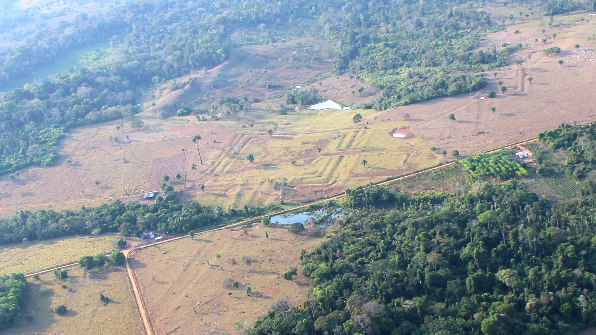
Hundreds of Ancient Amazon Geoglyphs Reveal the Scale of the Mysterious Aquiry Civilization
Using lidar and airborne laser-scanning technology, archaeologists have discovered hundreds of previously unknown ancient earthworks hidden beneath the dense canopy of Brazil’s Amazon rainforest. The findings offer new insight into the complex society that built them more than 2,000 years ago.
The civilization, known as the Aquiry, emerged in the southwestern Amazon approximately 2,500 years ago. Based on the extraordinary number of geometric earthworks, or geoglyphs, across the region, researchers estimate that the Aquiry population may once have reached between 1.25 million and 3 million people.
“The cultures and societies that composed the Aquiry shared a common worldview and constructed ceremonial centers in a variety of monumental geometric forms,” Martti Pärssinen, an archaeologist at the University of Helsinki, told Live Science in an email. These monumental sites typically featured deep ditches surrounded by tall outer embankments.
Latest Videos FromLive Science
In a new study published in the journal Nature, Pärssinen and his colleagues surveyed nearly 1,740 square miles (4,500 square kilometers) of Amazon rainforest. Their research identified 396 previously undocumented geoglyphs and helped researchers estimate the wider extent of the Aquiry civilization.
Pärssinen has studied ancient geometric earthworks in Brazil’s Acre state for more than 20 years. In a previous study, he introduced the name Aquiry for this multicultural Amazonian civilization. The name comes from the Acre River, which flows from Peru and Bolivia through modern-day Brazil. In the language of the Indigenous Arawakan people, Aquiry means “river of caimans.”
The thick rainforest canopy has made traditional archaeological surveys difficult. As a result, much of what researchers know about the Aquiry comes from lidar scans, which use laser pulses from aircraft to map the ground beneath the vegetation. The geoglyphs were built between approximately 600 B.C. and A.D. 850.
Archaeological evidence suggests that Aquiry communities lived in large, multifamily longhouses near the earthworks. They cultivated crops such as maize and squash and organized their settlements around monumental ceremonial centers.
“According to native oral traditions, the Aquiry centers were built to foster relations among communities” and with important supernatural beings, Pärssinen said. The sites may also have hosted large gatherings, political discussions and ceremonies where local chiefs demonstrated their generosity and influence.
Researchers have identified approximately 1,700 Aquiry geoglyphs so far, but that number may represent only a fraction of the total. Based on areas that have not yet been surveyed, the team estimates that more than 20,000 ancient earthworks could be scattered across the southwestern Amazon.
The researchers estimate that constructing and maintaining each geoglyph required an average workforce of about 300 people. This calculation suggests that the Aquiry civilization reached its greatest population between A.D. 100 and 300, when as many as 1.25 million to 3 million people may have lived across the region.
The scale of the Aquiry earthworks is changing how archaeologists understand precolonial societies in the Amazon. Rather than being sparsely populated wilderness, parts of the rainforest may have supported large, organized communities with extensive agriculture, ceremonial architecture and regional networks.
Somewhat similar geoglyphs, including large geometric designs and straight lines, were created in Peru between 200 B.C. and A.D. 500. These better-known monuments are called the Nazca Lines and include images of animals, people, plants and mythical figures. However, the Nazca lived around 1,050 miles (1,700 kilometers) from the Aquiry and appear to have been part of a separate cultural tradition.
“The Nazca geoglyphs represent a different phenomenon and were probably unrelated to the Aquiry civilization,” Pärssinen said. “Nevertheless, in both cases, the straight roads and lines, as well as the geometric forms and motifs, are best appreciated from the air.”
The discovery of thousands of Amazonian geoglyphs is prompting archaeologists to reconsider the development of cities, agriculture and political power in precolonial South America. At the same time, the findings raise a major question: What caused the Aquiry civilization to disappear?
The geoglyphs appear to have been abandoned relatively quickly between A.D. 850 and 950. “We do not know why the geoglyphs were suddenly abandoned,” Pärssinen said. The collapse may have occurred during a period of wider disruption that also affected other major precolonial societies, including the Classic Maya in Central America and the Tiwanaku and Wari civilizations in the Andes.
Pärssinen, M., Kalliola, R., Ranzi, A., Puttonen, E., Lopes, R.C., Virtanen, P.K., Apurinã, F., Ruokolainen, K., Hyyppä, J., Kukko, A., Campos, M., de Novaes, F., Oinonen, M., Barbosa, A.D., Saunaluoma, S., Ferreira, E. (2026). Over 20,000 precolonial earthworks in the Southwest Amazonia. Nature.
How much do you know about the first people to reach the Americas? Find out with our First Americans quiz!