


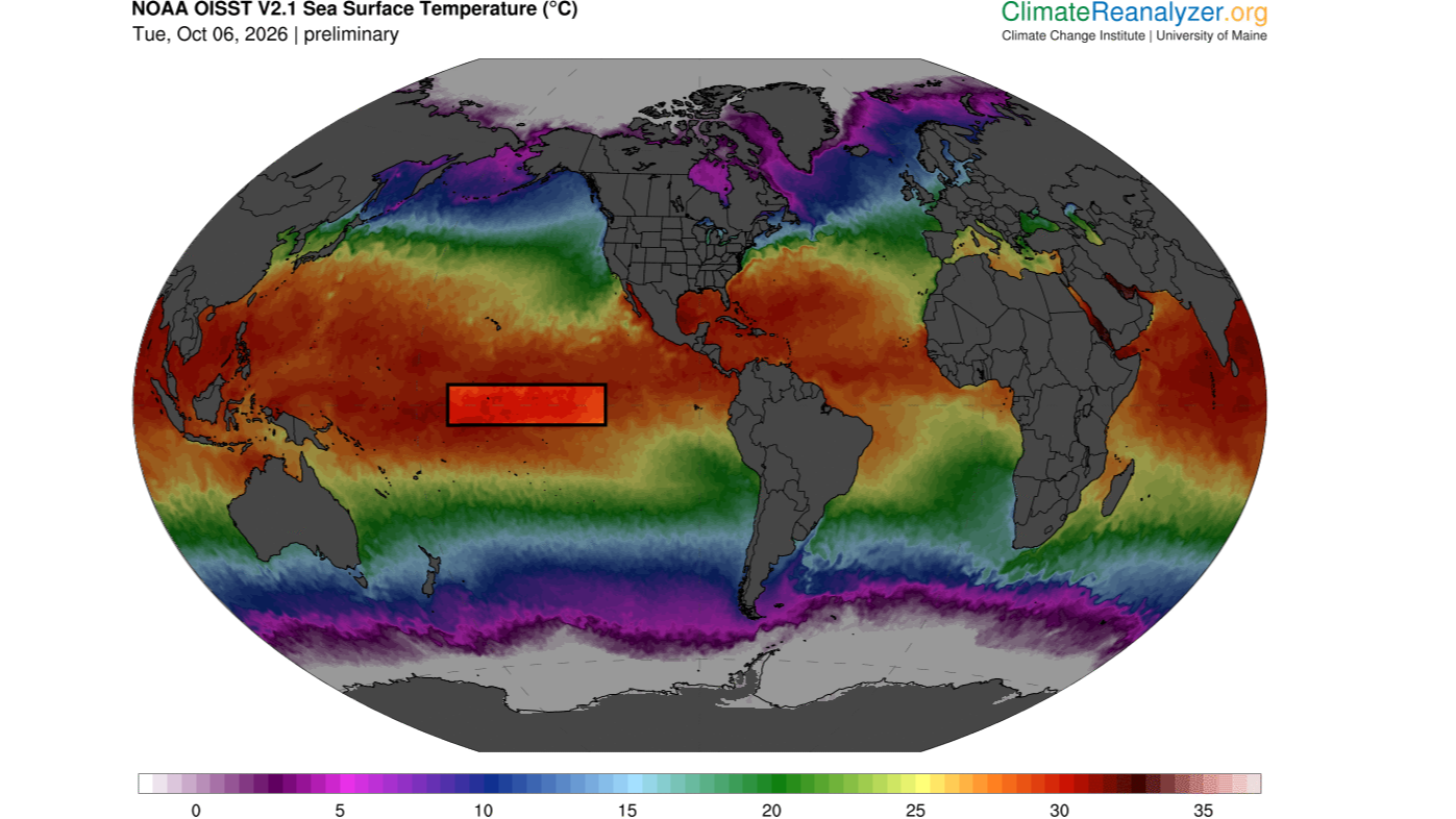
El Niño Sea Temperatures Break 86°F Record in the Pacific
Sea surface temperatures in the Niño 3.4 region of the central equatorial Pacific have exceeded 86 degrees Fahrenheit (30 degrees Celsius) for the first time, according to preliminary data released Monday, October 5.
The record warmth is being observed in the Niño 3.4 region, which stretches from 5°N to 5°S latitude and from 120°W to 170°W longitude. Scientists use this area to track the development and strength of El Niño, a natural climate pattern that is currently intensifying.
The new record raises an important question: Is this an unusually powerful El Niño, and could climate change make extreme events like it more common?
Why 86°F is unusual in the Niño 3.4 region
Sea surface temperatures above 86°F are common at this time of year in the warm pools of the western Pacific Ocean, northeast of Australia. However, the Niño 3.4 region is farther east and typically has considerably cooler waters.
Recent data show that conditions are “exceptionally warm for this region of the tropical Pacific Ocean,” according to Yoo Jin Yi, a professor of Earth system science at the University of California, Irvine.
“If the daily reported El Niño 3.4 temperature exceeds 30 degrees Celsius and is verified in the observational dataset, it will be an unusual record,” Yu told Live Science by email.
Other climate scientists agreed that the reading would be highly significant. A Niño 3.4 sea surface temperature above 86°F would represent a “very significant” record, said Timothy Osborn, professor of climate science and head of the Climate Research Unit at the University of East Anglia in the U.K.
Matt Collins, professor of climate systems and head of mathematics and statistics at the University of Exeter, also described the temperature as “very important.”
How strong is this El Niño?
Absolute sea surface temperature is not the standard measure scientists use to determine the strength of El Niño. Researchers typically compare temperatures in the Niño 3.4 region with the region’s long-term average or with temperatures in other tropical areas. The second approach helps account for the overall warming of the world’s oceans caused by climate change.
By those measures, the current event is already close to the strongest El Niño events on record, Osborn said. He added that the event could surpass previous records as it continues to develop and may already have broken records for this time of year by some measures.
What is a “super” El Niño?
El Niño occurs when warm water in the western tropical Pacific moves eastward along the equator toward South America. The shift changes atmospheric circulation and can raise global temperatures while disrupting rainfall patterns around the world.
El Niño can bring heavy rain and flooding to regions including East Africa and parts of South America. At the same time, drought can affect China, the southern United States, the equatorial Pacific coast of South America, Indonesia, the Philippines, southern Africa and northern South America.
“The effects of El Niño are greatest in the tropics and areas around the Pacific Ocean,” Osborn said. Record-strength events are particularly important because they can significantly disrupt atmospheric circulation, which controls weather and rainfall patterns.
As of October 6, temperatures in the Niño 3.4 region were approximately 6°F (3.34°C) above average and still rising. Typical strong El Niño events produce Niño 3.4 temperatures roughly 1.8 to 3.6°F (1 to 2°C) above average.
That makes the current event “extraordinary,” Yu said, describing it as a very strong, or “super,” El Niño.
Climate change may be amplifying the event
Human-caused global warming has raised the background temperature of the oceans, potentially amplifying the current El Niño. Sea surface temperatures in the Niño 3.4 region are expected to continue rising in the coming weeks, reaching a peak in November or December before falling again in 2027, Collins said.
Yu agreed that the Niño 3.4 temperature anomaly is likely to remain very large and may increase further. Some forecasts suggest temperatures could reach 7.2°F (4°C) above average by November.
Could extreme El Niño events become more common?
Scientists are examining whether the current event offers a glimpse of what future El Niño events could look like in a warmer world.
Future El Niño events may be more extreme than those of the past, Collins said. However, not every event is expected to be as dramatic as the current record-breaking episode because El Niño events vary considerably in strength and behavior.
Osborn noted that climate change could intensify the effects of El Niño even before the event begins. For example, regions already becoming drier because of global warming could face catastrophic drought if El Niño brings additional drying. Likewise, areas experiencing more rainfall could see more severe flooding when El Niño strengthens precipitation.
That does not necessarily mean that extreme El Niño events will become the new normal, Osborn said.
Research led by Yu and his colleagues suggests that El Niño may also be changing in location and duration. Scientists have identified two broad types: eastern Pacific El Niño and central Pacific El Niño. While earlier El Niño events were more often dominated by warming in the eastern tropical Pacific, central Pacific events have become more prominent in recent decades and may last longer.
Global warming could be strengthening interactions between the atmosphere and ocean in the subtropical Pacific, helping produce unusually intense warming in the central Pacific. These interactions may increase the likelihood of extreme El Niño events in a warmer climate.
However, Yu emphasized that this does not mean every El Niño event will become progressively stronger. The strength, location and duration of future events will continue to vary.
Source: www.livescience.com